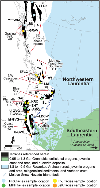
Figure 1.
Map illustrating present-day location of terranes discussed in this paper, age distribution of Laurentian Precambrian crust, and detrital zircon sample locations: SEYTT—Southeastern Yukon-Tanana terrane; YTT-CM—Yukon-Tanana terrane in Coast Mountains; GRAV—Gravina Belt; MT—Methow-Tyaughton; EFLC—Easton-Fidalgo-Lummi-Constitution; YA—Yellow Aster; IG—Ingalls Graywacke; T-N—Tonga-Nooksack; LM—Lookout Mountain; CH—Coon Hollow; BT—Baker terrane; MI—Mitchell Inlier; SL—Snowshoe and Lonesome fms.; KRC—Klamath River Conglomerate; GAL—Galice; AMQ—Antelope Mountain Quartzite; EHT—Eastern Hayfork terrane; NFT—North Fork terrane; U-GVG—Upper Great Valley Group; T-GVG—“Tithonian” Great Valley Group; LDC-P—Lang-Duncan-Culberton allochthons and Picayune Valley Fm.; M-GVG—Middle Great Valley Group; MAR—Mariposa; JEK—Jurassic–Early Cretaceous; MPP—Mixed Proterozoic and Phanerozoic; and PPA—Paleoproterozoic and Archean. See Table DR1 for specific data sources 1 . Adapted from Gehrels (2001); Wyld and Wright (2001); DeGraaff-Surpless et al. (2002); Wyld et al. (2006); Brown and Gehrels (2007); Nelson and Gehrels (2007); base modified from Whitmeyer and Karlstrom (2007).