Full Text View
Volume 23 Issue 12 (December 2013)
GSA Today
Article, pp. 4-10 | Abstract | PDF (4.1MB)
The geological legacy of Hurricane Irene: Implications for the fidelity of the paleo-storm record
| Table of Contents |
|---|
|
Search GoogleScholar for
Search GSA Today |
 |
ABSTRACT
Paleotempestology has become more contentious in recent years because the exact nature of storm deposition and preservation is still poorly understood. Whereas historical records of hurricanes along the Atlantic coast are limited to the past 300 years, and reliable instrumental records extend back only half that length of time, proxy records taken from coastal sedimentary archives offer the potential to extend this record several thousand years, offering better statistical constraints on hurricane prediction. Two primary proxies have been the most studied during the last decade: sedimentary criteria and microfossils. In this study, we used a microfossil-based proxy—displaced marine foraminifers—to investigate a 1500-year paleostorm record of Onslow Bay, North Carolina, USA, and to compare marsh sediments and foraminifers pre- and post–Hurricane Irene, which made landfall in Onslow Bay on 27 August 2011. We found fewer hurricanes archived in the 1500 years of back-barrier marsh strata than have made landfall in Onslow Bay since 1950. This absence of preserved hurricane deposits, as well as the lack of a definitive signature from Hurricane Irene, suggests that caution should be used with respect to the sensitivity of sedimentological or micropaleontological proxies in paleotempestology studies. We conclude that, at best, only direct strikes from intense storms are being preserved, and it is likely Hurricane Irene’s landfall will not be detectable in the future in the marginal-marine sediments from this region.
*Email:
Manuscript received 26 Apr. 2013; accepted 1 July 2013
DOI: 10.1130/GSATG184A.1
Introduction
As coastal populations continue to grow, and as recent Gulf Coast hurricanes have dramatically demonstrated, there is a need for a better long-term record of storm frequency and impact. Such a record can be used to determine recurrence intervals, guide coastal infrastructure and commercial planning, and set cost-effective insurance rates. The unfortunate paucity of historical records for hurricane landfall along the southern Atlantic coast limits their use as a predictive tool. Only three Category 5 hurricanes have made landfall in the United States since 1900; as a result, the probability of such an extreme storm impacting this region cannot be accurately determined using instrumental records. At best, forensic (historical) records of hurricanes along the Atlantic coast are limited to the past 300 years (Elsner et al., 2000, 2008; Chenoweth, 2006, 2007; Nyberg et al., 2007), and reliable instrumental records extend back only half that length of time (Neumann et al., 1999). Proxy records taken from marginal-marine environments offer the potential to extend this record through the late Holocene, offering better statistical constraints on hurricane prediction.
Paleotempestology, the study of prehistoric tropical cyclone landfalls using geological proxies, is a relatively new and, in many instances, controversial science. One of the underlying goals of paleotempestological research is the compilation of landfall record of storms of all intensities (Categories 1–5) with high spatiotemporal resolution from the last several millennia from a disparate geographic region in order to better understand the recurrence interval of these natural hazards (Fig. 1). Assessment of the role of the El Niño Southern Oscillation (ENSO) (Goldenberg et al., 2001), the strength and position of the Bermuda High (Xie et al., 2005), and the role of increasing sea-surface temperatures on hurricane frequency (Kossin and Vimont, 2007) are also reliant on the development of an accurate and complete record of prehistoric storms.
|
Recent paleotempestology studies from the marginal-marine environments along the Atlantic, Caribbean, and Gulf coasts. |
Two paleotempestological proxies, based either on sedimentological or micropaleontological criteria (and rarely both), have received significant attention during the past decade, although other proxies, such as erosional indicators (Buynevich et al., 2007) and geochemical anomalies (McCloskey and Liu, 2012; Das et al., 2013) are being assessed. Many of these methodologies were discussed and debated during the well-attended theme session “Paleotempestology: Proxy Record Development and Climate Forcing Mechanisms” at The Geological Society of America’s 2012 Annual Meeting and Exposition in Charlotte, North Carolina, USA. The sedimentological proxy is based on identification of sediment transported into marshes and coastal lakes by hurricanes; it has been derided as “sand layer counting” and has been the subject of decade-long debates regarding the accuracy of the methodology (Liu and Fearn, 1993, 2000; Liu et al., 2008, 2009; Otvos, 2002, 2009, 2011). The micropaleontology method relies on transport of marine foraminifers into marshes during hurricane landfall. The micropaleontological proxy has also been the subject of several arguments—the exact taxa that are indicative of storm deposition and the completeness of the microfossil-derived storm records are still not well established (Hippensteel and Martin, 1999, 2000; Scott et al., 2003, 2005; Hippensteel et al., 2005; Hippensteel, 2011).
Previous sedimentological and micropaleontological approaches are problematic with respect to their actualistic approach, interpreting ancient storm deposits without a complete understanding of the modern dynamics of event deposition across marginal-marine environments. Geological signatures of recent hurricanes such as Rita, Katrina, and Ike have demonstrated that deposition varies greatly with respect to sedimentary characteristics and microfossil content (or lack thereof) (Horton et al., 2009; Williams 2009, 2010). Without a more complete understanding of hurricane deposition in marginal-marine environments, and the resulting archived storm record, criticism of “sand layer counting” or detection of “peripheral hurricane strikes” or minor hurricane landfalls will most likely continue.
In this study, we report on the Late Holocene hurricane record of Onslow Bay, North Carolina, and the modern sedimentological and foraminiferal signature of Hurricane Irene to provide insights into the preservation potential of storm deposits along the U.S. Atlantic Coast. Our underlying goal was to assess the usefulness of microfossils for the documentation of ancient hurricane strikes and to determine the suitability of such a proxy for creating an accurate record of prehistoric hurricanes of differing magnitudes.
The Paleo-Storm Record of Onslow Bay
During 2010, nine back-barrier marshes from Onslow Bay were cored to a 3-m depth in search of paleo-storm deposits (Fig. 2; see the GSA Supplemental Data Repository 1 for details regarding field and laboratory methodology). Marginal-marine sites were selected at different latitudes and distances from Onslow Bay to maximize the potential for finding a site with a large number of preserved storm deposits and minimize site sensitivity to storm deposition. Only two marshes, Alligator Bay and Tar Landing Bay, contained displaced marine foraminifers interpreted as storm deposits (Table 1). A total of ten storm layers, representing a minimum of four storms, were recovered at Tar Landing Bay, and 16 storm deposits (a minimum of five storms) were obtained at Alligator Bay (Fig. 2). Offshore indicative taxa from these storm layers included, in descending order of abundance, Quinqueloculina seminula, Cibicides sp., Nonionella sp., Spirilina sp., Wiesnerella sp., Quinqueloculina laevena, and Patellina sp. Although Elphidium spp. and Ammonia spp. are also common nearshore and shelf taxa in this region, their cosmopolitan nature prohibited their use as an indicator of storm transport and deposition. Sponge spicules, echinoid spines, and pteropods were also present in the sand layers. Radiocarbon analyses indicate that these layers were deposited during the past 1500 years (Fig. 3; see supplemental data [footnote 1]). No deposits that could be interpreted as tempestites were detected in the upper 3 m of the auger cores taken from the following back barrier localities: Battery Buchanan marsh, Fort Fisher marsh, Wrightsville Beach marsh, Bear Island marsh, and South Core Banks marsh.
|
Location of the nine marshes cored in search of paleostorm deposits and the path of Hurricane Irene (28–29 Aug. 2011). |
1 GSA supplemental data item 2013357, field and laboratory methodology and radiocarbon analysis, is online at www.geosociety.org/pubs/ft2013.htm. You can also request a copy from GSA Today, P.O. Box 9140, Boulder, CO 80301-9140, USA; gsatoday![]() geosociety.org.
geosociety.org.
|
Record of storm deposits from nine marshes along Onslow Bay, North Carolina, USA, and the displaced offshore indicative foraminifers they contain. |
|
Composite storm history for Alligator Bay (ABAC) and Tar Landing Bay (adjacent to Fort Macon) (FMAC) for the previous ~1500 years. Yellow bars represent storm layers enriched with displaced marine foraminifers. |
Historically, Onslow Bay has had a similar or perhaps greater number of hurricane strikes as any other portion of the Atlantic and Gulf coastline. More than ten hurricanes made landfall in Onslow Bay since 1950, and a further 29 made landfall near or passed within 200 km of the shoreline (Table 2). Despite such historical storm activity, the prehistoric storm record archived in the marshes from Onslow Bay is poor. In Onslow Bay, only five to eight storm deposits have survived from the past 1500 years. Only two of these (at ~0.80 and ~2.30 m) are found at both Tar Landing Bay and Alligator Bay, and neither was detected at the other seven Onslow Bay marshes. The diminutive storm record could be the result of one or more of the following factors: (1) a lack of landfalls, (2) the destruction of storm signatures via bioturbation or erosion, or (3) the sensitivity of the sites to storm deposition (i.e., the distance [or elevation] between the marshes and the source of the sediments and foraminifers).
|
Record of hurricane to strike or pass through Onslow Bay since 1950. |
Quiescence or Destruction?
Storm layer preservation has recently been studied in the back-barrier system from Charleston, South Carolina (Hippensteel, 2011). Significantly different event horizons were found in cores only 10 m apart, and the lack of storm-layer preservation was attributed to a combination of bioturbation and dissolution of the calcareous foraminifers (Fig. 4).
|
Downcore abundance of coarse sand and offshore-indicative foraminifers from three cores taken 10 m apart on Folly Island, South Carolina, USA. Core FIAC-03 contained sedimentological and foraminiferal evidence of seven hurricane deposits while Core FIAC-08 contained sedimentological evidence of four hurricane strikes and offshore foraminifers were rare. Core FIAC-11 contained little or no evidence of hurricane strikes. The missing foraminifers in FIAC-08 were probably destroyed through dissolution, and the hurricane record of FIAC-11 was probably destroyed through a combination of dissolution (foraminifers) and bioturbation (sediments). |
Millennial periods of hurricane inactivity have been documented using sedimentary proxies (Liu and Fearn, 1993, 2000; Donnelly et al., 2004). Several reports discuss one landfall along Alabama and Florida during the past 1,000 years, in contrast to the previous 3,000 years in which as many as 12 Category 4 and 5 storms made landfall (Liu and Fearn, 1993, 2000). Similar records of dormancy from latitudes as disparate as Puerto Rico (Woodruff et al., 2008) and Massachusetts (Buynevich and Donnelly, 2006; Buynevich et al., 2007) have also been reported.
The lack of offshore indicative foraminifers in the cores, other than in the four or five storm layers, may be due to a number of reasons. For example, the lack of marine foraminifers in the sediments from Hurricanes Katrina and Rita was explained through possible post-burial alteration of the assemblages or on the minimal size of the standing crop of the source material (Horton et al., 2009).
The scarcity of storm deposits in the nine marshes from Onslow Bay can be attributed to the complex interaction of numerous pre- and post-burial mechanisms. These include the scarcity in foraminifers in the storm source material, ebb-tidal flow removing foraminifers from the deposit, the rate of retreat of many of the islands over the previous 1,500 years, as well as post-depositional destruction of the foraminiferal assemblage through dissolution. Bioturbation further hindered the preservation of the storm layers by both mixing the discrete sandy deposits into the overlying and underlying marsh deposits and increasing the rates of dissolution to the calcareous tests (Fig. 4). To further investigate potential causes for the lack of preserved tempestites, we assessed the composition of the deposits left behind by Hurricane Irene on the previously studied marshes from Onslow Bay, as well as the meteorological parameters across the depositional environments during the hurricane.
Geological Legacy of Hurricane Irene
Foraminifers were collected from multiple subenvironments from four marshes along Onslow Bay before and immediately after Hurricane Irene made landfall on 27 Aug. 2011 (Category 3 diminishing to Category 1 as it made landfall in Onslow Bay, 26–28 Aug. 2011) to determine the micropaleontological signature left by the storm (Fig. 2). These marshes had been repeatedly sampled during the earlier paleotempestology study, during which surface samples were collected for use as an analog for determining downcore paleoenvironments. As a result, we had both pre- and post-storm samples for comparison. Irene did not form sandy overwash deposits similar to those archived in many Atlantic coast marshes, nor did it produce back-barrier horizons containing significant numbers of displaced marine foraminifers indicative of storm deposition. Only one subenvironment, the tidal creek at Alligator Bay, received transported shallow-marine foraminifers, and this was the sole marsh with meteorological conditions that were ideal for transport of offshore foraminifers into back-barrier environments: a relatively high maximum onshore wind (18.5 m/s), a significant storm surge (0.94 m), and offshore winds. This spatio-laterally limited storm signature will probably not be detectable in the marsh strata from Onslow Bay in the future, even if it were to survive future bioturbation.
Although the four marshes in this study had different meteorological conditions during the hurricane (wind speed and direction, storm and ebb flow), the transport of foraminifers and post-storm change in their populations were similar (Figs. 5 and 6). Three trends were detected in the foraminifer populations: first, a decrease by a large factor after the hurricane (Fig. 6); second, after Irene made landfall, the pre-storm tidal creek and estuary taxa were mixed. This mixing was especially prevalent in the lower-elevation subenvironments; and finally, a general increase in Q. seminula in the tidal creek subenvironments after the storm. This species has apparently been increasing in abundance in recent decades in the nearshore estuaries of North Carolina (Pruitt et al., 2010).
As Hurricane Irene passed through Onslow Bay in August 2011, it first produced a peripheral strike (at Oak Island, Fort Fisher, and Alligator Bay) and then a direct, if minor, hurricane strike to Tar Landing Bay (Fig. 2). Regardless, based upon the foraminiferal signature, it appears the storm record will not be archived in the marsh strata from Onslow Bay. The paleostorm deposits that were preserved in the Tar Landing Bay and Alligator Bay marshes were probably larger storms that produced more robust and distinct sedimentary deposits that were capable of surviving bioturbation. It is also likely that there were numerous other small hurricane strikes that were not detected in the strata because the signature left behind (a mixing of the estuarine and marsh taxa such as was observed with Hurricane Irene) was not diagnostic of an event (i.e., definitively caused by storm activity) and may not be recognized as a sedimentological or micropaleontological signature of a storm.
|
Locations of core samples collected in this study. White dots represent cores taken at each locality; arrows indicate the range of wind directions 24 hours before and 24 hours after landfall of Hurricane Irene. (A) Tar Landing Bay; (B) Alligator Bay; (C) Fort Fisher; (D) Oak Island. Images courtesy Google Earth. |
|
Abundance of agglutinated, calcareous, and estuarine/marine foraminifers from four coring localities in Onslow Bay before and after landfall of Hurricane Irene. |
Reports regarding the variability of storm signatures and the lack of preservation of storm deposits, whether the result of bioturbation or foraminiferal dissolution, call for caution regarding the reliability of sedimentological and micropaleontological paleotempestology proxies. The lack of storm records in the marsh sediments from Onslow Bay suggests only the most robust storm deposits are archived; the lack of a definitive hurricane signature from Irene, except under ideal meteorological conditions, raises concerns about our current understanding of hurricane deposition and preservation in marginal-marine environments. Nevertheless, future hurricane strikes of greater magnitude, with their resulting sedimentological and micropaleontological signatures, may provide insights into the validity of these proxies for archiving larger storms.
Acknowledgments
The paleotempestology research presented in this article was funded by the North Carolina Sea Grant Program (proposal #R/CZS-36) and the manuscript’s focus was greatly improved by two anonymous reviewers.
References Cited
- Buynevich, I.V., and Donnelly, J.P., 2006, Geologic signatures of barrier breaching and overwash, southern Massachusetts, USA: Journal of Coastal Research, SI, v. 39, p. 112–116.
- Buynevich, I.V., FitzGerald, D.M., and Goble, R.J., 2007, A 1,500-year record of North Atlantic storm activity based on optically dated relict beach scarps: Geology, v. 35, p. 543–546, doi: 10.1130/G23636A.1.
- Chenoweth, M., 2006, A reassessment of historical Atlantic basin tropical activity, 1700–1855: Climatic Change, v. 76, p. 169–240, doi: 10.1007/s10584-005-9005-2.
- Chenoweth, M., 2007, Objective classification of historical tropical cyclone intensity: Journal of Geophysical Research, D, Atmospheres, v. 112, D5, p. D05101, doi: 10.1029/2006JD007211.
- Das, O., Wang, Y., Donoghue, J., Xu, X., Coor, J., Elsner, J., and Xu, Y., 2013, Reconstruction of paleostorms and paleoenvironment using geochemical proxies archived in the sediments of two coastal lakes in northwest Florida: Quaternary Science Reviews, v. 68, p. 142–153, doi: 10.1016/j.quascirev.2013.02.014.
- Donnelly, J.P., Butler, J., Roll, S., Wengren, M., and Webb, T., III, 2004, A backbarrier overwash record of intense storms from Brigantine, New Jersey: Marine Geology, v. 210, p. 107–121, doi: 10.1016/j.margeo.2004.05.005.
- Elsner, J.B., Liu, K.-B., and Kocher, B., 2000, Spatial variations in major U.S. hurricane activity: Statistics and a physical mechanism: Journal of Climate, v. 13, p. 2293–2305, doi: 10.1175/1520-0442(2000)013<2293:SVIMUS>2.0.CO;2.
- Elsner, J.B., Jagger, T.H., and Liu, K.-B., 2008, Comparison of hurricane return levels using historical and geological records: Journal of Applied Meteorology and Climatology, v. 47, p. 368–374, doi: 10.1175/2007JAMC1692.1.
- Goldenberg, S.B., Landsea, C.W., Mestas-Nunez, A.M., and Gray, W.M., 2001, The recent increase in Atlantic hurricane activity: Causes and implications: Science, v. 293, p. 474–479, doi: 10.1126/science.1060040.
- Hippensteel, S.P., 2011, Spatio-lateral continuity of storm overwash deposits in back barrier marshes: GSA Bulletin, v. 123, p. 2277–2294, doi:10.1130/B30261.1.
- Hippensteel, S.P., and Martin, R.E., 1999, Foraminifera as an indicator of overwash deposits, barrier island sediment supply, and barrier island evolution, Folly Island, South Carolina: Palaeogeography, Palaeoclimatology, Palaeoecology, v. 149, p. 115–125, doi: 10.1016/S0031-0182(98)00196-5.
- Hippensteel, S.P., and Martin, R.E., 2000, Foraminifera of storm-generated washover fans: Implications for determining storm frequency in relation to sediment supply and barrier island evolution, Folly Island, South Carolina, in Martin, R.E., ed., Environmental Micropaleontology: New York, Kluwer Academic/Plenum Publishers, p. 351–369.
- Hippensteel, S.P., Martin, R.E., and Harris, M.S., 2005, Records of prehistoric hurricanes on the South Carolina coast based on micropaleontological and sedimentological evidence, with comparison to other Atlantic Coast records: Discussion: GSA Bulletin, v. 117, p. 250–254, doi: 10.1130/B25535.1.
- Horton, B.P., Rossi, V., and Hawkes, A.D., 2009, The sedimentary record of the 2005 hurricane season from the Mississippi and Alabama coastlines: Quaternary International, v. 195, p. 15–30, doi: 10.1016/j.quaint.2008.03.004.
- Kossin, J.P., and Vimont, D.J., 2007, A more general framework for understanding Atlantic hurricane variability and trends: Bulletin of the American Meteorological Society, v. 88, p. 1767–1781, doi: 10.1175/BAMS-88-11-1767.
- Liu, K.-B., and Fearn, M.L., 1993, Lake-sediment record of late Holocene hurricane activities from coastal Alabama: Geology, v. 21, p. 793–796, doi: 10.1130/0091-7613(1993)021<0793:LSROLH>2.3.CO;2.
- Liu, K.-B., and Fearn, M.L., 2000, Reconstruction of prehistoric landfall frequencies of catastrophic hurricanes in northwestern Florida from lake sediment records: Quaternary Research, v. 54, p. 238–245, doi: 10.1006/qres.2000.2166.
- Liu, K.-B., Lu, H., and Shen, C., 2008, A 1,200-year proxy record of hurricanes and fires from the Gulf of Mexico coast: Testing the hypothesis of hurricane–fire interactions: Quaternary Research, v. 69, p. 29–41, doi: 10.1016/j.yqres.2007.10.011.
- Liu, K.-B., Lu, H., and Shen, C., 2009, Some fundamental misconceptions about Paleotempestology: Quaternary Research, v. 71, p. 253–254, doi: 10.1016/j.yqres.2008.11.001.
- Neumann, C.J., Jarvinen, B.R., McAdie, C.J., and Hammer, G.R., 1999, Tropical cyclones of the North Atlantic Ocean, 1871–1998, 5th Revision: National Climate Data Center, Asheville, DOC/NOAA Historical Climatology Series 6–2, 206 p.
- Nyberg, J., Malmgren, B.A., Winter, A., Jury, M.R., Kilbourne, K.H., and Quinn, T.M., 2007, Low Atlantic hurricane activity in the 1970s and 1980s compared to the past 270 years: Nature, v. 447, p. 698–701, doi: 10.1038/nature05895.
- Otvos, E.G., 2002, Discussion of “Prehistoric Landfall Frequencies of Catastrophic Hurricanes…” (Liu and Fearn, 2000): Quaternary Research, v. 57, p. 425–428, doi: 10.1006/qres.2002.2333.
- Otvos, E.G., 2009, Discussion of “A 1200-year proxy record of hurricanes and fires from the Gulf of Mexico coast…” (Liu et al., 2008): Quaternary Research, v. 71, p. 251–252, doi: 10.1016/j.yqres.2008.11.002.
- Otvos, E.G., 2011, Hurricane signatures and landforms—Toward improved interpretations and global storm climate chronology: Sedimentary Geology, v. 239, p. 10–22, doi: 10.1016/j.sedgeo.2011.04.014.
- Pruitt, R.J., Culver, S.J., Buzas, M.A., Reide Corbett, D., Horton, B.P., and Mallinson, D.J., 2010, Modern foraminiferal distribution and recent environmental change in Core Sound, North Carolina, USA: Journal of Foraminiferal Research, v. 40, p. 344–365, doi: 10.2113/gsjfr.40.4.344.
- Scott, D.B., Collins, E.S., Gayes, P.T., and Wright, E., 2003, Records of prehistoric hurricanes on the South Carolina coast based on micropaleontological and sedimentological evidence, with comparison to other Atlantic Coast records: GSA Bulletin, v. 115, p. 1027–1039, doi: 10.1130/B25011.1.
- Scott, D.B., Collins, E.S., Gayes, P.T., and Wright, E., 2005, Reply: Records of prehistoric hurricanes on the South Carolina coast based on micropaleontological and sedimentological evidence, with comparison to other Atlantic Coast records: GSA Bulletin, v. 117, p. 254–256, doi: 10.1130/0016-7606(2005)117<254:R>2.0.CO;2.
- Williams, H.F.L., 2009, Stratigraphy, sedimentology and microfossil content of Hurricane Rita storm surge deposits in Southwest Louisiana: Journal of Coastal Research, v. 254, p. 1041–1051, doi: 10.2112/08-1038.1.
- Williams, H.F.L., 2010, Storm surge deposition by Hurricane Ike on the Mcfaddin National Wildlife Refuge, Texas: Implications for paleotempestology studies: Journal of Foraminiferal Research, v. 40, p. 210–219, doi: 10.2113/gsjfr.40.3.210.
- Woodruff, J.D., Donnelly, J.P., Mohrig, D., and Geyer, W.R., 2008, Reconstructing relative flooding intensities responsible for hurricane-induced deposits from Laguna Playa Grande, Vieques, Puerto Rico: Geology, v. 36, p. 391–394, doi: 10.1130/G24731A.1.
- Xie, L., Yan, T., Pietrafesa, L.J., Morrison, J.M., and Karl, T., 2005, Climatology and inter-annual variability of North Atlantic hurricane tracks: Journal of Climate, v. 18, p. 5370–5381, doi: 10.1175/JCLI3560.1.

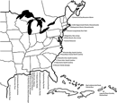 Figure 1
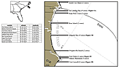 Figure 2
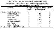 Table 1
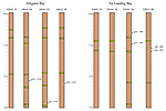 Figure 3
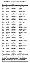 Table 2
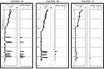 Figure 4
 Figure 5
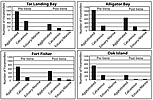 Figure 6