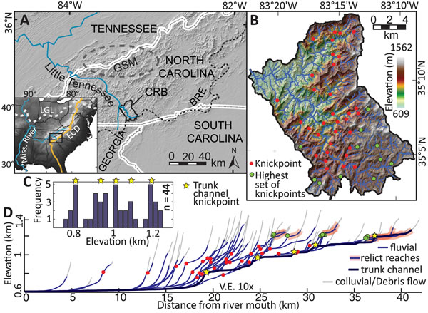
Figure 1.
(A) Shaded relief map of the southern Appalachians of western North Carolina and eastern Tennessee, USA. BRE (black dashed line)—Blue Ridge Escarpment; GSM (gray dashed oval)—Great Smoky Mountains. Inset map shows the location of this region in the context of the eastern continental divide (ECD) and the southern limit of glaciation during the last glacial maximum (LGL) (Thelin and Pike, 1991). The headwaters of the Cullasaja River basin (CRB) are >1500 km from the outlet of the Mississippi River. (B) Shaded relief image of the Cullasaja basin with the position of the 44 knickpoints identified in this study. (C) Histogram of knickpoint elevations in 25 m bins. Yellow stars denote the elevations of the trunk channel knickpoints identified in D. (D) Longitudinal river profiles of 52 streams showing the location of 44 knickpoints, relict reaches, and the approximate transition between fluvial and colluvial/debris flow–dominated channels that occurs at drainage areas ≥1.25 × 10⁵ m2. Red dots—knickpoints; green dots—highest knickpoints