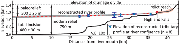
Figure 3.
Modern and reconstructed paleo-river profiles with the modeled elevations of tributary-trunk channel junctions projected to the paleo profile. The 2σ elevation errors are from the normalized steepness indices and are based on linear regressions through log-log channel slope-drainage area data (Fig. DR2 [see text footnote 1]). The amount of paleo-relief in the Cullasaja River basin is based on the assumption that the ridge lines have eroded at a rate commensurate with the mean denudation rate of the relict surface (6 ± 6 mm kyr−1).