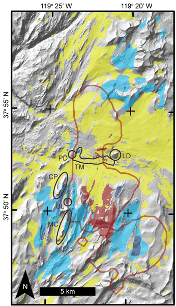
Figure 3.
Geologic map draped on Tuolumne Meadows’s topography (see Fig. 1 for location). Red regions represent Johnson Granite Porphyry outcrops. The rest of the map area is mostly Cathedral Peak Granodiorite. The red line represents the inferred subsurface extent of the Johnson Granite Porphyry (after Titus et al., 2005), which correlates well with the distribution of tabular fracture clusters (TFCs; blue). Light blue indicates low TFC density (2–5 m spacing) and dark blue indicates high TFC density (<2 m spacing) (after Riley and Tikoff, 2010). Yellow signifies Quaternary sediment cover. Tuolumne Meadows proper (TM) is indicated, as are Budd Lake (BL), Cathedral Peak (CP), Lembert Dome (LD), Matthes Crest (MC), and Pothole Dome (PD). Tuolumne Meadows is inferred to overlay highly fractured bedrock that was preferentially eroded by glaciation (see text for details).