
Full Text View
Volume 24 Issue 3 (March 2014)
GSA Today
![]()
Article, pp. 4-11 | Abstract | PDF (278KB)
125th anniversary of The Geological Society of America: Looking at the past and into the future of science at GSA
| Table of Contents |
|---|
|
Search GoogleScholar for
Search GSA Today |
| View past Presidential Addresses. |
2013 GSA Presidential Address
Delivered at the GSA Annual Meeting in Denver, Colorado, USA, on Sunday, 27 October 2013.

ABSTRACT
In the 125th year of The Geological Society of America, it is appropriate to look at the past accomplishments and the future of the Society. With this comes the understanding that it is through curiosity-driven geoscience, whose promotion and communication are hallmarks of GSA, that strides are made in understanding resources, hazards, the global environment, and the factors that influence our survival on planet Earth. Over the years, these advances have come from deductive reasoning based on new and accumulated field and laboratory observations and theoretical modeling, which are continuously taken to new levels by incorporating the latest scientific technology. With this in mind, we examine advances in understanding the origin of mountain belts in the context of the formation and evolution of Earth as our governing concepts have evolved from geosynclinal theory to plate interactions and continental collisions to concepts of continental lithospheric growth and destruction by processes like lower crustal and lithospheric delamination and forearc subduction erosion.
*Email:
DOI: 10.1130/GSAT-13PresAdrs.1
Introduction
One of the main reasons for the formal founding of The Geological Society of America more than 125 years ago, in 1888, at Cornell University in Ithaca, New York, USA, was to serve as a venue for communication and publications in the geological sciences. A further practical reason was to move the principal annual meeting out of the summer field session as was the practice when meeting with section E of the American Association for the Advancement of Science. Into this framework came the tradition of a presidential address to be delivered at the annual meeting. In looking at the addresses in the past 124 years, there seems to be no limit as to the topics—each address reflects the personality and interest of the president and the time.
Over the years, addresses have centered on the varied facets of geoscience as noted by 1966 GSA President Robert F. Leggett in 1966 (published in 1967), but even in the early years, some were on education, service, and the state of society—with Shaler on education in 1895 (published in 1896); Stevenson on the history of the Society in 1898 (1899); Penrose on “Geology and human welfare” in 1930 (1931); and Collins on “Geology and literature” in 1934 (1935). If we do a survey over the years, we find a large number of addresses on the geology of continents, the structure and tectonics of mountain belts, magmatism and surface processes, with the latest by Joaquin Ruiz on “A renaissance in earth sciences from the core of the Earth to the top of the mountains” in 2010 (not published, but his PowerPoint slides are online [last accessed 6 Jan. 2014]). Because this is the 125th anniversary of GSA, I thought I would address the evolution of thought on the continental geological framework as reflected by GSA presidential addresses over the past 125 years, with an eye to the future.
As such I will discuss the transition from geosynclines to plate tectonics to the geologic processes of continents as we see them today, because this in many ways reflects both the history of the geological sciences and the Society. There is in some sense a logical progression—essentially the geosynclinal theory came from observations on the continents, plate tectonics from adding observations on the oceans, and the new directions today from enhanced observations of Earth’s interior. A driver of all these ideas has been the advances in technology that have allowed us increasingly to see both smaller and larger segments of Earth, track and isolate its chemical signals, and more precisely measure its movements and temporal evolution.
The Geosyncline Era—Studies of the Continents
To start, it is appropriate to consider geosynclines in a historical context as James Hall, the Society’s first president, is credited with being the founder of the geosynclinal theory that dominated geologic thinking up until plate tectonics emerged near the GSA’s 75th birthday. The geosynclinal theory is also historical, as pointed out by Robert Dott (1978), because it was the first major geological concept made in America. The framework for an Appalachian geosyncline was put forth by Hall in his AAAS presidential address in 1857, but not published until 1882, because Joseph Henry cautioned him to go slowly in advocating such new ideas. Hall (1859, 1882) postulated that localized sedimentary loading caused the crust to subside and form a sediment-filled trough with the future mountain range following the trend of the deepest part of the trough. Down-warping of the trough was proposed to cause material to flow laterally under the rising mountain chain. James Dwight Dana, who became GSA’s first vice president, called the crustal down-warp the geosynclinal region and argued that collapse of the geosyncline by great folds produced by lateral pressure formed the mountain chain called a synclinorium (e.g., Dana, 1873). The compressed crust moved into the region of the future mountain range. Basically, there was a preparatory stage in which sediments accumulated, sourced from an old or border land, and a secondary stage in which these strata were folded and faulted. The Hall-Dana geosynclinal theory was elaborated on in various forms until the advent of plate tectonics in the late 1960s and early 1970s.
“The sites and nature of North American geosynclines” were described by Schuchert in his GSA presidential address in 1922. The published version (Schuchert, 1923) has more than 125 citations in Google Scholar, which is a large number for a publication of that vintage. The map in Figure 1A illustrates the concept of the old lands or borderlands that were the sediment sources on the borders of the geosynclines. There was no information on what lay below the oceans. Another important component of the geosynclinal theory was that the continents were fixed. The borderlands were given names like Siouis and Llanoris. Part of Llanoris and some of the southeast borderlands are now considered to have been rifted away to form the Cuyania terrane in modern Argentina, as discussed by William Thomas in his 2005 presidential address (Thomas, 2006).
|
Images of North American Paleozoic geosynclines. (A) Map of North American geosynclines from Schuchert (1924) with stippled areas showing geosynclinal troughs and the white areas as the borderlands (or old lands), which were considered to be the sediment source areas. (B) Cross section across the northern Appalachians after Kay (1951, redrafted by King, 1959) in region of red bar in A showing sediments in the miogeosyncline to the west, volcanic and sedimentary rocks in the eugeosyncline to the east, and the Vermontia tectonic land. |
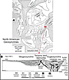 Figure 1
A comprehensive study on North American geosynclines by 1970 Penrose medalist Marshall Kay was published as GSA Memoir 48 in 1951 and subsequently reprinted three times and translated into four languages. It has more than 600 citations on Google Scholar. Kay incorporated the miogeosyncline and eugeosyncline names of Stille (1941) and illustrated them in a cross section (see Fig. 1B) across the northern Appalachians in the region where the Hall-Dana geosyncline concept had been developed. The miogeosyncline includes the down-warped sediments in a trough to the west, and the deeper eugeosyncline contains immature sandstones, lava flows, and basic igneous intrusives (Steinmann’s trinity: serpentine, pillow lavas, and chert) to the east. They are shown separated by the mountains of the Vermontia tectonic land. Kay emphasizes that not all American geosynclines fit this simple model and the growing complexities are indicated by his list of geosynclinal types (Zeugo, Exo, Auto, Epieu, Taphro, and Paralia). In Memoir 48, Kay (1951) provided a North American map for the Ordovician in which he showed clouds blowing in the wind on the borderlands to indicate poetically the uncertainties in those regions.
The importance of the geosynclinal theory until the 1960s is shown in the 1944 GSA presidential address of Adolph Knopf titled “The geosynclinal theory.” In the 1948 publication of his address, he states, “From … examination it appears that the geosynclinal doctrine is likely to prove to be a great unifying principle, possibly one of the greatest in geologic science” (p. 667). The theory was well-rooted in textbooks all around the world into the 1960s. An abbreviated quote from the historical geology text of Clark and Stearn (1960) reads, “The geosynclinal theory is one of the great unifying principles in geology … of fundamental importance to … all branches of geological science. The geosynclinal origin of major mountain systems is an established principle in geology” (p. 43). It is clear that caution is needed in making such proclamations.
The geosynclinal theory was commonly mentioned in GSA presidential addresses through the late 1940s, like those of Gilluly in 1948 (published in 1949), Longwell in 1949 (1950), Woodring in 1953 (1954), Bucher in 1955 (1956), Billings in 1959 (1960), Hedberg in 1960 (1961), and Krauskopf in 1967 (1968). The last president to mention geosynclines was Rodgers in 1970 (1971), who was on the cusp, as he also talked about plate tectonics theory.
One of the regions where the geosyncline concept of North America and Europe did not work well was in South America, where the central Andes seemed quite different. Albert Heim, for one, noted that unlike European geosynclines, marine and continental flysch were essentially absent, andesitic magmatism was pervasive, open and low-amplitude folds prevailed, and high P-T metamorphic assemblages were largely absent (MacLaren and Duff, 1993). Aubouin and Borrello (1966) suggested calling the central Andes a liminal chain to emphasize the difference.
Through the years, the geosynclinal model grew in complexity and away from unifying principles. A real problem was that there seemed to be a wide variety of geosynclinal styles and stages with no real general model and no clear testable driving mechanism that caused the mountains to form. Another problem was what happened to the borderlands on the edges of continents that magically disappeared into the oceans. The geosynclinal theory required older rocks in the borderlands to serve as source regions for the geosynclinal belts, yet both younger and older rocks were being found on continental margins. At the same time, there were strong geologic arguments that the continents had moved. Among early proponents were Alfred Wegener in Germany, Juan Keidel in Argentina, and Alexander Du Toit in South Africa. By 1960, the fit of the continents was widely discussed, and some ancient mountain belts separated by oceans seemed to have been connected. The discussion was particularly evident in the southern continents, where the Paleozoic to Mesozoic SAMFRAU (South America to Africa to Australia) geosyncline was postulated, with the recognition that the Paleozoic to Mesozoic paleontological links had disappeared by the Cenozoic. Other evidence for connections and breakups came from Paleozoic glacial sediments and paleomagnetic data. Opposition to continental drift came largely from a lack of a viable mechanism, and, perhaps, a northern hemisphere–centric view of much of the research community. The chinks were forming in the armor of the geosynclinal theory.
The Plate Tectonics Era—Incorporating The Oceans
By the 1960s, the ocean basins were being explored with an increasing number of seismic and magnetic techniques, and the ocean floor was being cored and dated. Among early pioneers were Penrose medalists Harry Hess (1966) and Maurice Ewing (1974) and Day medalist Fred Vine (1968) and collaborator Drum Matthews. Contrary to the geosynclinal hypothesis, the ocean floor was found to be young and basaltic. The new data and evolving plate tectonic theory showed that the ocean floor was continuously forming at ocean ridges and subducting beneath the continental margins. These observations allowed the continents to move, removing the objection to continental drift.
The theory of plate tectonics, which joined continental drift with seafloor spreading, led to the plate tectonic revolution of the 1960s and 1970s, with all of the problems of geosynclines seeming to disappear—as did geosynclinal theory. Jack Bird and 1992 Penrose medalist John Dewey put the classic northern Appalachian geosyncline into the plate tectonic framework (Bird and Dewey, 1970). Among many key players were GSA Penrose medalists J.T. Wilson in 1968, Robert Dietz in 1988, and A.E. Ringwood in 1974, and 1987 GSA president Jack Oliver in 1998.
The plate tectonics revolution can be seen in the GSA presidential addresses, with the word geosyncline disappearing after John Rodgers in 1970, who also used plate tectonics in addressing “The Taconic orogeny” (1971). Since that time, almost all addresses have mentioned plate tectonics.
The concepts of plate tectonics, including seafloor spreading, subduction and volcanic arcs, continental collisions, plumes, and hotspots, are taught universally in geoscience curriculums today and are commonly used in documentaries and the public news media. Many have said in parallel with statements on the geosynclinal theory, “Plate tectonic theory is a great unifying principle of fundamental importance to all branches of the geological science.” A question to ponder is what will be said 50 years from now.
Beyond Plate Tectonics—Whole Earth Views
As with the era of geosynclines, the plate tectonic era began with a simple view of how to explain mountain-building processes and continents in a unified framework. Out of plate tectonics has grown a whole new set of questions whose origins are closely connected with an ever-expanding technology that has allowed us to constrain timing and look deep into the Earth. Technological advances have led to an explosion of age constraints, particularly connected with precise U/Pb dating of zircons (“a miracle mineral”), Ar/Ar technology, and a host of other methods leading to temporal precision not before possible. Notable advances in geochemistry and geophysics have expanded our ability to track material at the surface and deep into the interior with new imaging techniques providing views of Earth’s interior that were unimaginable 50 years ago. Advances in computer technology allow manipulation of huge databases and production of endless strings of numerical models.
I will highlight a few of the frontier areas in looking at the Earth and into its interior where our understanding of tectonic processes is ongoing and hotly debated. These frontiers include recycling of continental crust through sediment subduction and forearc subduction erosion at convergent margins, foundering of mantle lithosphere and dense crust under arcs and continents (delamination), implication of ultra-high pressure (UHP) metamorphic signatures in upper crustal rocks for the subduction of continental crust, and the ultimate fate of subducted slabs and continental crust and lithosphere.
The first of these areas is the question of sediment subduction and forearc subduction erosion, which remove continental crust at convergent margins. In overview papers, von Huene and Scholl (1991), Clift and Vannucchi (2004), and Scholl and von Huene (2007) argue that most active subduction zones (>80%) are erosional, with pieces of the overriding plate plucked from the hanging wall and subducted to unknown depths. The general model for subduction erosion after von Huene et al. (2004) is shown in Figure 2A. The quantities of sediment subducted and forearc removed, along with their ultimate fate, are currently hotly debated topics. Amounts of recycled crust are commonly expressed in Armstrong Units (after Dick Armstrong) with 1 AU being 1 km3/yr. Proposed global removal amounts by subduction erosion have varied from 1.1 to 1.7 AU. Scholl and von Huene (2007) pointed out that at these rates, the volume of continental crust today would be recycled by subduction erosion in less than 2.5 billion years. Stern (2011) and others argue that geochemical analyses show that arc magmatism brings back no more than 10% of the subducted crust. Some overall estimates suggest that at modern rates the crust is actually shrinking, although actual long-term loss depends on many factors. Forearc subduction erosion along with continental rifting aids in solving the old borderlands problems of the geosyncline era.
The South American margin (see Fig. 2B) is commonly singled out in discussions of forearc subduction erosion because the concept arose there to explain the eastward stepping of the late Jurassic to recent arc, which cannot be explained by strike-slip tectonics. The conjecture is that ~200 km of the margin has been lost in the last 200 million years (Rutland, 1971). More recently, much of the loss has been suggested to be episodic. Some suggested that short-term local rates are 96–128 km3/m.y./km for the past 10 m.y. (Laursen et al., 2002) near the Juan Fernandez ridge (Fig. 2B), with the highest rate yet suggested of ~440 km3/my/km at the Chile ridge-trench triple junction further south near 46°S latitude (Bourgois et al., 1996).
|
Images for forearc subduction erosion. (A) Figure adapted from von Huene et al. (2004) and Goss and Kay (2006) showing the general model for forearc subduction–eroded material transported in the subduction channel between the upper and lower plate. (B) Relief map of the Andes showing the Chile trench, the subducting Nazca and Juan Fernandez aseismic ridges on the Pacific plate, and the high central Andean Puna–Altiplano plateau and surrounding flat-slab regions. The green line shows the approximate position of the Chile trench at ca. 200 Ma given that the trench has migrated eastward in response to forearc subduction erosion as tracked by the eastward displacement of the magmatic arc (e.g., Scholl and von Huene, 2007). The yellow arrows point to regions of forearc subduction erosion pulses at 8–3 Ma on the Chilean margin and today on the Ecuadorian margin. (C) Google Earth image illustrating the proposed ~40–50 km displacement of the Chilean trench between 27°S and 34°S to compensate for the eastward displacement of the magmatic arc (Kay et al., 2005; Goss et al. 2013; see text). |
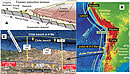 Figure 2
Looking at a specific Andean example (Figs. 2B and 2C), 40–50 km of the Chilean forearc near 34°S and 27°S on the margins of the amagmatic Pampean-Chilean flat-slab appears to have been removed by subduction erosion between 8 and 3 Ma, with much of the evidence coming from a 40–50-km eastward displacement of the frontal arc and the distinctive “adakitic” geochemical signatures of the contemporaneous magmas (Kay et al., 2005; Goss et al., 2013). Given a constant ~300-km arc-trench gap and subduction erosion across the intervening flat slab (Fig. 2C), a major pulse of subduction erosion at a rate of >190 km3/my/km affected ~700 km of the margin from 8 to 3 Ma, during the time of the most rapid shallowing of the flat slab (Kay and Mpodozis, 2002). Several intriguing observations are related. One is the suggestion of Allmendinger et al. (1990) that a potential crustal mass balance problem with the 137 km of crustal shortening that they calculated in a transect at 30°S could be solved by forearc subduction erosion. Another is that the low seismic Vp/Vs ratios in the mantle wedge above the flat-slab attributed to orthopyroxene related to sediment subduction by Wagner et al. (2008) is actually related to forearc crust entering the mantle wedge as the slab shallowed.
A second area of heated discussion is delamination or gravity-driven foundering of dense continental lithosphere into the underlying mantle. The original hypothesis was by Peter Bird (1979) to explain thinning of the mantle lithosphere in the western U.S. associated with Laramide shallow subduction. Lithospheric removal can also explain thinned lithosphere, uplift, volcanism, and changes in deformation patterns as argued in Tibet in papers by England, Houseman, Molnar, and others (e.g., England and Houseman, 1989). Linking the delamination of mantle lithosphere with that of cold, dense mafic lower crust helped to provide a viable sinker as well as an explanation as to why the bulk composition of the crust is andesitic (Kay and Kay, 1993). These suggestions were initially received with skepticism, but recognition of a thinner mantle lithosphere than expected from contractional shortening in orogenic regions, unexpected high elevation, and distinctive magmatic patterns and chemistry has led to a proliferation of suggested and debated delamination sites.
In North America, continental lithospheric removal has been most discussed under the Sierra Nevada and Great Basin and the Colorado Plateau, with evidence coming from xenoliths, field and modeling studies, and seismic studies. The problem of an andesitic crust had long been recognized in the Sierra Nevada, and the studies of Zandt, Saleeby, Ducea, and coworkers (e.g., Zandt et al., 2004) have suggested the cause is the delamination of lower crust. Recent seismic images in Gilbert et al. (2012) and Saleeby et al. (2012) show what is interpreted to be a foundered, but likely still attached, lithospheric block (“drip”) extending to depths of >100 km under the Great Valley in California. Another debated example put forth by Levander et al. (2011) is an interpreted lithospheric drip reaching a depth of 250 km on the southwestern edge of the Colorado plateau. Various western U.S. seismic anomalies seen with EarthScope transportable seismic array data are being interpreted by Humphreys and other workers (e.g., Schmandt and Humphreys, 2011) as residual pieces of the subducted Farallon plate.
It is in the central Andean Puna–Altiplano plateau (Fig. 3A), which stands at an elevation of >3700 m, that some of the most intense discussion on lithospheric delamination has taken place and where some of the most convincing evidence exists. The original Kay et al. (1994) hypothesis for delamination of crustal and mantle lithosphere in a transect near 26°S, shown in the cartoon in Figure 3B, was based on the criteria used for lithospheric delamination in Tibet, with additional constraints from the geochemistry of the lavas. Seismic evidence was lacking at the time, but this has changed as studies have proliferated throughout the central Andes.
|
Images for delamination of crust and mantle lithosphere. (A) Relief map showing the central Andean Puna–Altiplano plateau and central volcanic zone (CVZ) arc with the black box bounding areas where continental and crustal lithospheric delamination has been imaged. (B) Cartoon cross section at 26°S from Kay and Kay (1993) showing delaminated crustal (yellow) and lithospheric mantle (striped) under the backarc beneath the 6–2 Ma Cerro Galán ignimbrite caldera. (C) Surface wave tomographic image (in %Vs) based on Calixto et al. (2013) in an east-west transect at 26°S showing low velocity region (blue) interpreted as delaminated block above slab (dashed line). (D) Image modified from Calixto et al. (2013) showing delaminated block above the subducting slab under Cerro Galán. Dots are earthquake hypocenters; open and red circles are the best located. |
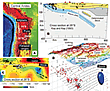 Figure 3
The now popular lithospheric-scale cartoon in Beck and Zandt (2002) based on seismic studies in the southern Altiplano near 19°S shows a gap in the continental lithosphere attributed to removal under a crustal region thought to contain melt. This gap is attributed to delamination, although there is no evidence as to what happened to the missing piece. Subsequent seismic images further south near 23–24°S shown by Schurr et al. (2006) reveal a low-velocity region in the mantle above the subducting slab, which they interpret as a delaminated block. An overlying low-velocity region is attributed to decompression melting above the delaminated block. With these images, the delamination model gained credibility in the Andes, with the size and frequency of the blocks or drips still being hotly debated topics today.
Some of the most recent evidence for delamination in the Puna plateau comes from the Vs tomographic image from Calixto et al. (2013) at latitude 26°S, which is at the same latitude and shown at the same scale as the Kay et al. (1994) cross section (Fig. 3B). The high-velocity area in blue above the inferred slab is interpreted to be the delaminated block, with the overlying low-velocity anomaly in red attributed to a zone of partial melt below the giant Cerro Galan ignimbrite caldera. A 3-D perspective of the delaminated block is shown in Figure 3D.
A third emerging research area is associated with exhumation of continental crust that has been subjected to ultra-high pressure (UHP) metamorphism. A key in recognizing these terranes is the presence of minerals like coesite and diamond. In a review, Hacker et al. (2013) describe how observed UHP terranes range from large or small, can be exhumed at plate tectonic or slower rates, can be variably deformed, may or may not be associated with melting, and can have different thermal histories. They investigate the various proposed origins with numerical modeling and conclude that UHP terranes form by a wide variety of mechanisms, some of which may not have yet been imagined. Most models associate UHP metamorphism with subduction of continental margins because the P-T conditions fit, and subduction zones provide the pathway. The most common model following Chemenda et al. (1995) (Fig. 4A) is for a thin crustal sheet to be detached from a block of subducted continental lithosphere at ~100 km depth and then be rapidly exhumed as convergence proceeds. However, this model cannot explain the large eastern China Dabie–Sulu terrane or the Western Gneiss Region terrane in Norway, which show evidence for slow subduction and exhumation histories of tens of millions years without strong deformation. A proposed “eduction” model following Anderson et al. (1991) (Fig. 4B) calls for a reversal of relative motion of the down-going plate in association with slab breakoff. A third type of UHP is seen in Papua New Guinea, where metamorphism appears to postdate subduction by >20 million years. A working model following Little et al. (2011) (Fig. 4C) shows this UHP terrane being exhumed as a diapir.
|
Images of numerical models to explain ultra-high pressure metamorphism in continental crust (UHP terranes) from a review by Hacker et al. (2013). Scale for all is in patterned box in B. (A) Subducted piece of the upper continental crust at a collisional margin detached at ~100–150 km depth and exhumed by buoyancy before slab breakoff. (B) Exhumation of a large block on a normal fault as motion reverses after slab breakoff. (C) UHP rocks rise through the mantle as a diapir, resulting in relamination. Modified from Anderson et al., 1991; Chemenda et al., 1995; Hacker et al., 2013; and Little et al., 2011. |
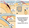 Figure 4
Another question is assessing the flux of silicic continental material that enters the mantle and returns to the base of the continental crust. In one scenario, Hacker et al. (2011) argue that silicic rocks transform into felsic gneisses that form melts and then rise buoyantly to “relaminate” to the base of the crust. They envision relamination of subducted sediment, subducted intra-oceanic arc crust, forearc subducted crust, and subducted continental crust. Quantitative tests await crustal mass balance for these models.
A final question is the quantity of continental crust and lithosphere that is subducted or delaminated into the convecting mantle, and the fate of this material. Some have argued for dispersal of foundered continental lithosphere in the upper mantle after breakup of supercontinents. Evidence as to whether crust also enters the deeper mantle is centered on the chemistry of ocean-island basalt (OIB). Many geochemists have argued that the chemical variability of OIB can be adequately explained by subducted ocean crust and sediments. However, some like Willbold and Stracke (2010) now argue that lower continental crust removed by forearc subduction erosion and/or delamination is required, because recycling of marine sediments alone cannot completely account for features like positive Eu anomalies and lower crustal-like isotopic signatures. The only way to obtain such signatures from subducted sediments is the unlikely erosion of large, unobserved tracts of exhumed lower crust, whereas subduction erosion and delamination provide a way for lower crust to enter the mantle. Willbold and Stracke point out that erosive margins like the Andes seem to require removal of crust, and that lower crust is sufficiently dense and dry to sink with the slab into the deep mantle without melting. If plate tectonics has operated since the late Archean, sufficient recycled continental material can enter the deep mantle to explain the range of signatures in OIBs. They consider two end-member possibilities to explain the OIB chemistry. In the first, continental crust is transported deep into the mantle by subduction and brought up in plume magmas generated in a locally mixed mantle. In the second, the plume is derived from a stirred marble cake mantle containing delaminated crust and subducted slabs.
Herein, we have only looked at a few of the present frontiers. Among many other questions are the following: Do plumes really exist? What is the role of supercontinent cycles? How did the early Earth evolve? How did the core form and how do magnetic reversals work? When did plate tectonics begin? What is the history of crustal growth? Advances in all of these areas will come from deductive reasoning based on new and accumulated field and laboratory observations and theoretical modeling—all continuously taken to new levels by the latest technology.
Final Remarks
With this short overview of studies of the American Cordilleras and the continents and oceans, we see an evolution of geoscience theory that will continue into the future as new ideas enhance the understanding of our planet and have implications for hazards, resources, sustainability, climate change, and other unknown challenges.
Compared to the GSA founders in 1888, we have a more global view today and face an increasing challenge to follow a rapidly expanding scientific database and scholarly literature. What tomorrow will bring is for our successors at future GSA meetings to tell in the scientific communication style of the time.
REFERENCES CITED
- Allmendinger, R.W., Figueroa, D., Snyder, D., Beer, J., Mpodozis, C., and Isacks, B.I., 1990, Foreland shortening and crustal balancing in the Andes at 30°S latitude: Tectonics, v. 9, p. 789–809, doi: 10.1029/TC009i004p00789.
- Andersen, T.B., Jamtveit, B., Dewey, J.F., and Swensson, E., 1991, Subduction and eduction of continental crust: Major mechanisms during continent-continent collision and orogenic extensional collapse, a model based on the south Norwegian Caledonides: Terra Nova, v. 3, p. 303–310, doi: 10.1111/j.1365-3121.1991.tb00148.x.
- Aubouin, J., and Borrello, V.A., 1966, Chaînes alpines et chaines Andines: Regard sur la géologie de la cordillère des Andes au parallèle de l’Argentine moyenne: Paris, Bulletin de la Société Géologique de France, 7º Série, VIII, p. 1050–1070.
- Beck, S.L., and Zandt, G., 2002, The nature of orogenic crust in the central Andes: Journal of Geophysical Research, v. 107, 2230, doi: 10.1029/2000JB000124.
- Billings, M.P., 1960, Diastrophism and mountain building: GSA Bulletin, v. 71, p. 363–398, doi: 10.1130/0016-7606(1960)71[363:DAMB]2.0.CO;2.
- Bird, J.M., and Dewey, J.F., 1970, Lithosphere plate–continental margin tectonics and the evolution of Appalachian orogen: Geological Society of America Bulletin, v. 81, p. 1031–1059, doi: 10.1130/0016-7606(1970)81[1031:LPMTAT]2.0.CO;2.
- Bird, P., 1979, Continental delamination and the Colorado Plateau: Journal of Geophysical Research, v. 84, p. 7561–7571, doi: 10.1029/JB084iB13p07561.
- Bourgois, J., Martin, H., Lagabrielle, Y., Le Moigne, J., and Frutos, J., 1996, Subduction erosion related to spreading-ridge subduction: Taitao peninsula (Chile margin triple junction area): Geology, v. 24, p. 723–726, doi: 10.1130/0091-7613(1996)024<0723:SERTSR>2.3.CO;2.
- Bucher, W.H., 1956, Role of gravity in orogenesis: GSA Bulletin, v. 67, p. 1295–1318, doi: 10.1130/0016-7606(1956)67[1295:ROGIO]2.0.CO;2.
- Calixto, F.J., Sandvol, E.A., Kay, S.M., Mulcahy, P., Heit, B., Yuan, X., Coira, B., Comte, D., and Alvarado, P.M., 2013, Velocity structure beneath the southern Puna plateau: Evidence for delamination: Geochemistry Geophysics Geosystems, v. 14, doi: 10.1002/ggge.20266.
- Chemenda, A.I., Mattauer, M., Malavieille, J., and Bokun, A.N., 1995, A mechanism for syn-collisional rock exhumation and associated normal faulting: Results from physical modelling: Earth and Planetary Science Letters, v. 132, p. 225–232, doi: 10.1016/0012-821X(95)00042-B.
- Clark, T.H., and Stearn, C.W., 1960, The Geological Evolution of North America: A Regional Approach to Historical Geology: New York, Ronald Press Co., 434 p.
- Clift, P.D., and Vannucchi, P., 2004, Controls on tectonic accretion versus erosion in subduction zones: Implications for the origin and recycling of the continental crust: Reviews of Geophysics, v. 42, RG2001, doi: 10.1029/2003RG000127.
- Collins, W.H., 1935, Geology and literature: GSA Bulletin, v. 46, p. 355–374.
- Dana, J.D., 1873, On some results of the Earth’s contraction from cooling including a discussion of the origin of mountains and the nature of the Earth’s interior: American Journal of Science, series 3, v. 5, p. 423–443, doi: 10.2475/ajs.s3-5.30.423.
- Dott, R.H., 1978, Tectonics and sedimentation a century later: Earth-Science Reviews, v. 14, p. 1–34, doi: 10.1016/0012-8252(78)90040-5.
- England, P., and Houseman, G., 1989, Extension during continental convergence, with application to the Tibetan Plateau: Journal of Geophysical Research, v. 94, p. 17,561–17,579, doi: 10.1029/JB094iB12p17561.
- Gilbert, H., Yang, Y., Forsyth, D.W., Jones, C., Owens, T., Zandt, G., and Stachnik, J., 2012, Imaging lithospheric foundering in the structure of the Sierra Nevada: Geosphere, v. 8, p. 1310–1330, doi: 10.1130/GES00790.1.
- Gilluly, J., 1949, Distribution of mountain building in geologic time: GSA Bulletin, v. 60, p. 561–590, 10.1130/0016-7606(1949)60[561:DOMBIG]2.0.CO;2.
- Goss, A.R., and Kay, S.M., 2006, Steep REE patterns and enriched Pb isotopes in southern Central American arc magmas: Evidence for forearc subduction erosion?: Geochemistry Geophysics Geosystems, v. 7, Q05016, doi: 10.1029/2005GC001163.
- Goss, A.R., Kay, S.M., and Mpodozis, C., 2013, Andean adakites from the northern edge of the Chilean-Pampean flat-slab (27–28.5°S) associated with frontal arc migration and forearc subduction erosion: Journal of Petrology, v. 54, p. 2193–2234, doi: 10.1093/petrology/egt044.
- Hacker, B.R., Kelemen, P.B., and Behn, M.D., 2011, Differentiation of the continental crust by relamination: Earth and Planetary Science Letters, v. 307, p. 501–516, doi: 10.1016/j.epsl.2011.05.024.
- Hacker, B.R., Gerya, T.V., and Gilotti, J.A., 2013, Formation and exhumation of ultrahigh-pressure terranes: Elements, v. 9, p. 289–293, doi: 10.2113/gselements.9.4.289.
- Hall, J., 1859, Description and figures of the organic remains of the Lower Helderberg group and the Oriskany sandstone: New York Geological Survey: Paleontology, v. 3, p. 66–96.
- Hall, J., 1882, Contributions to the geological history of the American continent: American Association for the Advancement of Science, 31st Annual Meeting, Salem, Massachusetts, Salem Press, p. 29–69.
- Hedberg, H.D., 1961, The stratigraphic panorama (an inquiry into the bases for age determination and age classification of the Earth’s rock strata): GSA Bulletin, v. 72, p. 419–517, doi: 10.1130/0016-7606(1961)72[419:TSP]2.0.CO;2.
- Kay, M., 1951, North American Geosynclines: Geological Society of America Memoir 48, 143 p.
- Kay, R.W., and Kay, S.M., 1993, Delamination and delamination magmatism: Tectonophysics, v. 219, p. 177–189, doi: 10.1016/0040-1951(93)90295-U.
- Kay, S.M., and Mpodozis, C., 2002, Magmatism as a probe to the Neogene shallowing of the Nazca plate beneath the modern Chilean flat-slab: Journal of South American Earth Sciences, v. 15, p. 39–57, doi: 10.1016/S0895-9811(02)00005-6.
- Kay, S.M., Coira, B., and Viramonte, J., 1994, Young mafic back-arc volcanic rocks as guides to lithospheric delamination beneath the Argentine Puna Plateau, Central Andes: Journal of Geophysical Research, v. 99, p. 24,323–24,339, doi: 10.1029/94JB00896.
- Kay, S.M., Godoy, E., and Kurtz, A., 2005, Episodic arc migration, crustal thickening, subduction erosion, and magmatism in the south-central Andes: GSA Bulletin, v. 117, p. 67–88, doi: 10.1130/B25431.1.
- King, P.B., 1959, The Evolution of North America: Princeton, New Jersey, Princeton University Press, 190 p.
- Knopf, A., 1948, The geosynclinal theory: GSA Bulletin, v. 59, p. 649–669, doi: 10.1130/0016-7606(1948)59[649:TGT]2.0.CO;2.
- Krauskopf, K.B., 1968, A tale of ten plutons: GSA Bulletin, v. 79, p. 1–18, doi: 10.1130/0016-7606(1968)79[1:ATOTP]2.0.CO;2.
- Laursen, J., Scholl, D.W., and von Huene, R., 2002, Neotectonic deformation of the Central Chile margin: Deepwater forearc basin formation in response to hot spot ridge and seamount subduction: Tectonics, v. 21, 1038, doi: 10.1029/2001TC901023.
- Leggett, R.F., 1967, Soil: Its geology and use: GSA Bulletin, v. 78, p. 1433–1460, doi: 10.1130/0016-7606(1967)78[1433:SIGAU]2.0.CO;2.
- Levander, A., Schmandt, B., Miller, M.S., Liu, K., Karlstrom, K.E., Crow, R.S., Lee, C.T.A., and Humphreys, E.D., 2011, Continuing Colorado plateau uplift by delamination style convective lithospheric downwelling: Nature, v. 472, p. 461–465, doi: 10.1038/nature10001.
- Little, T.A., Hacker, B.R., Gordon, S.M., Baldwin, S.L., Fitzgerald, P.G., Ellis, S., and Korchinski, M., 2011, Diapiric exhumation of Earth’s youngest (UHP) eclogites in the gneiss domes of the D’Entrecasteaux Islands, Papua New Guinea: Tectonophysics, v. 510, p. 39–68, doi: 10.1016/j.tecto.2011.06.006.
- Longwell, C.R., 1950, Tectonic theory viewed from the basin ranges: GSA Bulletin, v. 61, p. 413–434, doi: 10.1130/0016-7606(1950)61[413:TTVFTB]2.0.CO;2.
- MacLaren, P., and Duff, D., editors, 1993, Holmes’ Principles of Physical Geology, fourth edition: New York, Chapman and Hall, 791 p.
- Penrose, R.A.F., 1931, Geology as an agent in human welfare: GSA Bulletin, v. 42, p. 393–406; reprinted in 2013 in GSA Today, v. 23, no. 7, p. 4–10, http://www.geosociety.org/gsatoday/archive/23/7/article/i1052-5173-23-7-4.htm (last accessed 6 Jan. 2014).
- Rodgers, J., 1971, The Taconic orogeny: GSA Bulletin, v. 82, p. 1141–1178, doi: 10.1130/0016-7606(1971)82[1141:TTO]2.0.CO;2.
- Rutland, R.W.R., 1971, Andean orogeny and ocean floor spreading: Nature, v. 233, p. 252–255, doi: 10.1038/233252a0.
- Saleeby, J., Le Pourhiet, L., Saleeby, Z., and Gurnis, M., 2012, Epeirogenic transients related to mantle lithosphere removal in the southern Sierra Nevada region, California, part I: Implications of thermomechanical modeling: Geosphere, v. 8, p. 1286–1309, doi: 10.1130/GES00746.1.
- Schmandt, B., and Humphreys, E.D., 2011, Seismically imaged relict slab from the 55 Ma Siletzia accretion to the northwest United States: Geology, v. 39, p. 175–178, doi: 10.1130/G31558.1.
- Scholl, D.W., and von Huene, R., 2007, Crustal recycling at modern subduction zones applied to the past—Issues of growth and preservation of continental basement crust, mantle geochemistry, and supercontinent reconstruction, in Hatcher, R.D., Jr., Carlson, M.P., McBride, J.H., and Martínez Catalán, J.R., eds., 4-D Framework of Continental Crust: Geological Society of America Memoir 200, p. 9–32.
- Schuchert, C., 1923, Sites and nature of the North American geosynclines: GSA Bulletin, v. 34, p. 151–230.
- Schuchert, C., 1924, A Textbook of Geology, Part II: Historical Geology: New York, John Wiley and Sons, 724 p.
- Schurr, B., Rietbrock, A., Asch, G., Kind, R., and Oncken, O., 2006, Evidence for lithospheric detachment in the central Andes from local earthquake tomography: Tectonophysics, v. 415, p. 203–223, doi: 10.1016/j.tecto.2005.12.007.
- Shaler, N.S., 1896, Relations of geologic science to education: GSA Bulletin, v. 7, p. 315–326, http://www.geosociety.org/aboutus/PresAddress/NSShaler.pdf (last accessed 6 Jan. 2014).
- Stern, C.R., 2011, Subduction erosion: Rates, mechanisms, and its role in arc magmatism and the evolution of the continental crust and mantle: Gondwana Research, v. 20, p. 284–308, doi: 10.1016/j.gr.2011.03.006.
- Stevenson, J.J., 1899, Our society: GSA Bulletin, v. 10, p. 83–98; reprinted in 2013 in GSA Today, v. 23, p. 4–11, http://www.geosociety.org/gsatoday/archive/23/8/pdf/i1052-5173-23-8-4.pdf (last accessed 6 Jan. 2014).
- Stille, H., 1941, Einfiihrung in den Bau Amerikas: Berlin, Borntraeger, 717 p.
- Thomas, W.A., 2006, Tectonic inheritance at a continental margin: GSA Today, v. 16, no. 2, p. 4–11, http://www.geosociety.org/gsatoday/archive/16/2/pdf/i1052-5173-16-2-4.pdf (last accessed 6 Jan. 2014).
- von Huene, R., and Scholl, D.W., 1991, Observations at convergent margins concerning sediment subduction, subduction erosion, and the growth of continental crust: Reviews of Geophysics, v. 29, p. 279–316, doi: 10.1029/91RG00969.
- von Huene, R., Ranero, C.R., and Vannucchi, P., 2004, Generic model of subduction erosion: Geology, v. 32, p. 913–916, doi: 10.1130/G20563.1.
- Wagner, L.S., Anderson, M.L., Jackson, J.M., Beck, S.L., and Zandt, G., 2008, Seismic evidence for orthopyroxene enrichment in the continental lithosphere: Geology, v. 36, p. 935–938, doi: 10.1130/G25108A.1.
- Willbold, M., and Stracke, A., 2010, Formation of enriched mantle components by recycling of upper and lower continental crust: Chemical Geology, v. 276, p. 188–197, doi: 10.1016/j.chemgeo.2010.06.005.
- Woodring, W.P., 1954, Caribbean land and sea through the ages: GSA Bulletin, v. 65, p. 719–732, doi: 10.1130/0016-7606(1954)65[719:CLASTT]2.0.CO;2.
- Zandt, G., Gilbert, H., Owens, T.J., Ducea, M., Saleeby, J., and Jones, C.H., 2004, Active foundering of a continental arc root beneath the southern Sierra Nevada in California: Nature, v. 431, p. 41–46, doi: 10.1038/nature02847.