
Full Text View
Volume 25 Issue 11 (November 2015)
GSA Today
![]()
Article, pp. 4-11 | Abstract | PDF (4.2MB)
Dismemberment and northward migration of the Cordilleran orogen: Baja-BC resolved
| Table of Contents |
|---|
|
Search GoogleScholar for
Search GSA Today |
ABSTRACT
Paleomagnetic results indicate that much of the North American Cordillera migrated more than 1000 km northward during the 80–58 Ma Laramide event, yet geologists cannot find either the faults along which such movement might have taken place or readily identifiable piercing points to document offset. Here, I suggest that the sinistral Texas Lineament, which extends west-northwest from the Gulf of Mexico to the Cordilleran fold-thrust belt southwest of Las Vegas, and the sinistral Lewis & Clark transverse zone, located about 1300 kilometers to the north, and extending from southern Vancouver Island east-southeast to the thrust belt in the Helena salient, can be restored to one through-going zone to provide a piercing point that constrains meridional migration. I interpret the zone as the result of plate interactions on a left-stepping transform margin formed along the southern margin of North America during Jurassic opening of the Atlantic Ocean. The structure was dismembered and partly transported northward along faults in and/or adjacent to the Cordilleran fold-thrust belt. The proposed restoration also reunites two conspicuous bands of Late Cretaceous–Paleocene slab-failure plutons and porphyry copper deposits into a single zone extending continuously along western North America. This reconstruction obviates the need for Laramide flat slab subduction.
Email:
Manuscript received 24 June 2015; accepted 17 July 2015.
doi: 10.1130/GSATG255A.1
Introduction
One of the more contentious aspects of North American Cordilleran tectonics is the possible meridional migration, based mostly on paleomagnetic evidence, of large sections of crust (Kerr, 1995). This is the so-called Baja-BC controversy, which was born when paleomagnetists discovered anomalously shallow paleomagnetic inclinations in Cretaceous rocks of the Canadian Cordillera relative to those obtained from rocks of cratonic North America (Beck and Noson, 1972; Irving, 1979, 1985). The data imply that a major portion of the coastal Cordillera of British Columbia migrated northward >1000 km between about 90 and 60 Ma (Irving, 1985; Irving et al., 1996; Enkin, 2006).
Geologists soon developed models that incorporated the paleomagnetic data (Umhoefer, 1987; Johnston, 2001, 2008; Butler et al., 2001; Umhoefer and Blakey, 2006; Hildebrand, 2013) but failed to present obvious matches between rocks of British Columbia and those much farther south. So, even though (1) paleomagnetic data were compelling (Beck 1991); (2) the method worked well elsewhere in the world (Mac Niocaill et al., 2003); and (3) the long-standing northerly orientation of the Cordilleran margin would seem to be ideal for paleomagnetic studies, the geological community hasn’t accepted that thousands of kilometers of translation had occurred because piercing points weren’t readily located and because geologists couldn’t identify the faults along which such large displacements took place (Kerr, 1995; Mahoney et al., 1999; Nelson et al., 2013).
In this contribution, I show that meridional migration within the Cordillera was not confined to narrow slivers along the coast, but instead involved the entire width of the Cordillera, from the Laramide fold-thrust belt westward, as hypothesized by Enkin et al. (2006a), Johnston (2008), and Hildebrand (2009, 2013). By utilizing simple cross-cutting relationships and two piercing points to constrain and support large-scale meridional migration, I bring the paleomagnetic data into consilience with the geological data to resolve the longstanding Baja-BC controversy.
Geology
Decades ago Phil King (King, 1969) divided the Cordillera into three along-strike sectors—northern, central, and southern—based on geological differences across two transverse boundaries: the Lewis & Clark transverse zone of Montana and Idaho and the Texas Lineament, which was considered to extend from the Transverse Ranges of California to the Gulf of Mexico. Regarding the southern boundary, he wrote (p. 72):
The zone is a strip of country as much as 160 km (100 miles) wide that separates two parts of the Cordillera with different topographies, geologic histories, and styles of deformation. South of the zone the Cordilleran foldbelt extends 800 km (500 miles) farther east than on the north side, and for long distances its deformed rocks closely adjoin little deformed rocks in the Colorado Plateau and the block mountains of New Mexico, which are reactivated or disrupted parts of the former craton. These contrasts have not been produced by transverse faulting, and the Texas Lineament is not a through-going fault zone, as has sometimes been assumed.
In my earliest paper on the Cordillera (Hildebrand, 2009), I noted the many changes along the southern margin of the Colorado Plateau and hypothesized that there must be a fault, which I called the Phoenix fault, separating the non-extended Colorado Plateau from the extended zone to the south. At the time, I was unaware of King’s boundaries and was flummoxed because I could not decide whether the fault was transform or transcurrent. For example, it was obvious that, in addition to the thrust belt, the Neogene Basin and Range structural province occurs much farther west, north of the lineament, than its equivalent in Mexico (Fig. 1), yet I knew that it couldn’t be a younger transcurrent fault because 18.8 Ma Peach Spring Tuff (Fig. 1) crops out in a narrow band from Arizona to near Barstow, California (Glazner et al., 1986) and extends unbroken over the trace of the zone.
|
Geological sketch map of west-central North America showing the two transverse structural zones and geologically relevant units. Geology from Reed et al. (2004) with local detail from sources cited in the text; 80 Ma contours of Cretaceous rocks from Roberts and Kirschbaum (1995); Great Basin calderas from Henry and John (2013); Late Cretaceous-Paleocene Sri isopleths from Armstrong et al. (1977). Inset: The Gulf of Mexico region simplified from Reed et al. (2004) showing the sinistral separation of Gulf salt (reflected in salt domes) and the southward truncation of the high-amplitude magnetic high that is interpreted to represent basalts of a volcanic rifted margin (Mickus et al., 2009). The Mexican ridges province is characterized by detachments in shale, whereas elsewhere in the Gulf, detachments are in salt (Rowan et al., 2004). |
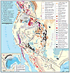 Figure 1
Besides the separation of the Basin and Range and the thrust belt, many other features display sinistral separation across the lineament (Fig. 1): The post-Sevier dynamic basin (as illustrated by the 80 Ma isopachs), the Laramide belt of porphyry copper deposits (Gilmer et al., 2003), and possibly the Oligocene ignimbrite flare-up (Henry and John, 2013) all show sinistral separation. The oldest rocks that show obvious sinistral separation across the zone are the Callovian salt deposits of the Gulf of Mexico (Fig. 1).
Features restricted to the region north of the Texas Lineament include the Colorado Plateau, the Rio Grande rift, the High Plains province, and the Ouachita-Marathon orogen. Features largely limited to the region south of the lineament include the Sonoran batholith, related porphyry Cu deposits, and the Pinal schist (Fig. 1).
The Rio Grande rift disappears southward into the Mexican Basin and Range, whereas the unbroken High Plains just west of the 100th meridian trend southerly into the Mexican Basin and Range (Figs. 1 and 2). Paleozoic features, such as the Ouachita-Marathon fold-thrust belt and strata of the Permian Basin, are truncated and do not appear south of the lineament, whereas the much younger Late Cretaceous–Paleocene Sonoran batholith extends northward into Arizona but remains mostly south of the lineament and extends westward through the Transverse Ranges, where it ends (Fig. 1). The northwesterly tip of the Texas Lineament zone is obscure and cannot be traced beyond the area just southwest of Las Vegas, where the Cordilleran fold-thrust belt also appears to terminate in the complexly faulted Mojave region of eastern California (e.g., figure 14 in Burchfiel et al., 1992).
|
Simplified map showing many of the main Cordilleran elements discussed in the text. Rotation of Colorado Plateau from Kent and Witte (1993). |
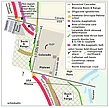 Figure 2
The Lewis & Clark transverse zone (Fig. 1), which King (1969) used to separate the central from the northern Cordillera, is similar to the Texas Lineament in that it ends at the Laramide thrust belt, and most units north and south display sinistral separation or are truncated against it (Figs. 1 and 2). Late Cretaceous–Paleocene magmatic rocks in Idaho and Montana, of which the Idaho and Boulder batholiths are examples, continue north of the zone but display a sinistral step before continuing farther northward through the High Cascades and the Coast plutonic complex of British Columbia (Fig. 1).
Following the same trends as the plutonic rocks is the prominent left step in the initial Sr isopleths of Late Cretaceous–Paleocene rocks (Armstrong et al., 1977; Fleck and Criss, 1985). A few plutons of a 100–80 Ma plutonic belt—interpreted farther south as slab-failure plutons related to the 100 Ma Oregonian event (Hildebrand and Whalen, 2014)—occur within the Idaho batholith and to the west in the Cascades and Coast plutonic complex north of the zone. Eocene magmatism and core complexes (Foster et al., 2007) also display a sinistral separation across the zone (Fig. 1), whereas three other Cenozoic groups of rocks—dikes and lavas of the Columbia River Basalt Group (Reidel et al., 2013), volcanic and sedimentary rocks of the Ancestral Cascades (du Bray and John, 2011), and dominantly basaltic rocks of Siletzia (Wells et al., 2014)—all abut northward against the zone (Figs. 1 and 2). The classic Laramide basement uplifts and basins (Fig. 1), characteristic of the central Cordillera, are largely confined to the area south of the Lewis & Clark zone and north of the Texas Lineament (Fig. 1).
Based on the absence of sinistral separation across them, rocks of the Belt Supergroup appear to sit atop the Lewis & Clark transverse zone, but the zone expresses itself in the overlying Belt rocks with a linear band of abundant faults, folds, and intense cleavage (Wallace et al., 1990; Sears, 1988). A conspicuous band of Late Cretaceous sedimentary rocks located west and south of the Boulder batholith (Fig. 1) is an order of magnitude thicker, and is stratigraphically quite different, south of the zone than correlative rocks to the north in the Montana disturbed belt (Wallace et al., 1990). Jurassic-Cretaceous rocks of the Tyaughton-Methow basin (Umhoefer et al., 2002), and those of the Upper Cretaceous Nanaimo basin on Vancouver Island (Mustard, 1994) do not continue south of the transverse zone (Fig. 1).
Baja-BC Resolved
Several robust and repeatable paleomagnetic studies exist for the region north of the Lewis & Clark zone. I summarize the results of several, plus an interesting study of leaf fossils that yielded congruent results, in Figure 3. The results are similar, but those from older Cretaceous rocks have slightly larger amounts of displacement relative to the craton, largely because North America started to move southward at 90 Ma (Kent and Irving, 2010).
|
Google Earth® map showing key paleomagnetic results for mid- to Upper Cretaceous rocks and separation of Late Cretaceous–Early Cenozoic Laramide slab failure rocks. Symbols without inner black dots are current locations, whereas those with dots are their paleomagnetically restored latitudes. Note that restoring the Lewis & Clark zone with the Texas Lineament is consistent with the paleomagnetic data and also reunites the Laramide magmatic belt. Leaf margin data from Miller et al. (2006); Nanaimo points from Kent and Irving (2010) and Kim and Kodama (2004); Carmacks from Enkin et al. (2006a); Silverquick–Powell Creek from Enkin et al. (2006b); Fernie, British Columbia (BC), from Enkin et al. (2000); Blue Mountains from Housen and Dorsey (2005). |
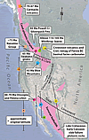 Figure 3
A breakthrough in our understanding occurred through paleomagnetic study of the Carmacks Group (Fig. 3), which yielded ca. 70 Ma paleopoles indicating 1950 ± 600 km northward translation relative to cratonic North America (Enkin et al., 2006a). The group is an amalgamation of 72–69 Ma volcanic and sedimentary rocks located in the Canadian Cordillera north of Whitehorse (Fig. 3). Rocks of the group sit unconformably on rocks of the Yukon-Tanana terrane, which collided and joined with Cassiar platform and Selwyn basin during the Late Permian (Berenek and Mortensen, 2011); were all overlapped by Triassic conglomerate (Berenek and Mortensen, 2007); and cut by abundant mid-Cretaceous plutons (Rasmussen, 2013). Thus, the paleomagnetic results from much younger rocks of the Carmacks Group apply to those terranes as well (Gladwin and Johnston, 2006). The results, supported by data from earlier, but less conclusive, studies farther south in the Canadian Front Ranges (Enkin et al., 2000) led Randy Enkin to conclude that the majority of northward translation took place on “unidentified structures located east of the Selwyn basin” (Enkin et al., 2006a).
Paleomagnetic studies farther south in Albian-Cenomanian turbiditic rocks of the Blue Mountain terranes, Oregon, yielded paleopoles 1760 ± 460 km discordant to North American poles at about 93 Ma (Housen and Dorsey, 2005). Rocks of the Blue Mountains–Riggins terranes were joined to rocks of the Belt Supergroup along the Salmon River suture between 111 and 90 Ma (Manduca et al., 1993; Unruh et al., 2008), and, because rocks of the Belt Supergroup form one giant allochthon (Sears, 2007; Fuentes et al., 2012) that was thrust over Upper Cretaceous sedimentary rocks in the Cordilleran fold-thrust belt, the paleomagnetic results from the Ochoco Basin should apply to rocks of the Belt Supergroup as well. These results are consistent with the Carmacks results and together indicate that northward migration of the entire Cordilleran tectonic collage took place along faults within or east of the Cordilleran fold-thrust belt after about 70 Ma.
I recognized (Hildebrand, 2013, 2014) that the 125–105 Ma Sevier event was separate and distinct from the 80–58 Ma Laramide event and confined to the Great Basin sector of the orogen. And, based on geological and geophysical features, such as the distribution of eastwardly vergent thrusts, the lack of an arc on North American crust, and compelling new mantle tomography (Sigloch and Mihalynuk, 2013), I argued that subduction was westerly dipping. I also noted that slab-failure magmatism and thrust faults related to the Sevier event are not found in the Great Basin west of the fold-thrust belt where expected, but instead are located in the Canadian Cordillera. This, along with the Carmacks paleomagnetic data, and evidence that the Laramide foredeep migrated northward during the latest Cretaceous–Paleocene (Cataneanu et al., 2000; Roberts and Kirschbaum, 1995), led me to argue that the entire Cordillera migrated northward during the Laramide event (Hildebrand, 2014). However, other than the band of likely slab-failure plutons and the mismatched thrust belts, I presented no real piercing points, so the arguments, although cogent to some, were not compelling to all.
The left-stepping nature of the geology along both the Lewis & Clark transverse zone and the Texas Lineament, their similar orientations, and the observation that both appear to be truncated at the Laramide fold-thrust belt, suggest that the two zones were once continuous and separated during the Laramide event on one or more faults in, or adjacent to, the thrust belt. Currently, the two zones are ~1300 km apart. Paleomagnetic studies from the Carmacks volcanics and the Blue Mountains terranes have paleopoles 1760 ± 460 and 1950 ± 600 km discordant to cratonic North America, respectively (Housen and Dorsey, 2005; Enkin et al., 2006a) so they support the geological restoration. Thus, the transverse zones provide a piercing point consistent with the paleo-magnetic data (Fig. 3).
I propose that the restored transverse zone represents a step in the southern margin of North America, and—because the oldest known rocks to exhibit sinistral separation across the zone are Callovian salt deposits beneath the Gulf of Mexico—that it formed as a sinistral transform fault during Jurassic opening of the central Atlantic Ocean. The northwest extent of the zone is located today around southern Vancouver Island, but the Cordilleran fold-thrust belt terminates just southwest of Las Vegas and to the south resumes ~800 km farther east, as noted by King (1969). South of the zone, terranes collided with North America much farther east than to the north, but the overall geology is similar in many respects simply because some of the same events took place on both sectors of the continental margin. Others, such as deformational features related to the 125–110 Ma Sevier event, have no recognized counterpart to the south because the impinging block, which Stephen Johnston and I (Johnston, 2008; Hildebrand, 2013) argued to have been a ribbon continent, did not arrive there until much later, as suggested by the coincidence of the distinctive eastward-extending prong of the mantle fast-zone (Sigloch and Mihalynuk, 2013), and the meridionally restored location of the Great Basin region, at about 125 Ma (Hildebrand, 2014).
A major Late Cretaceous–Paleocene magmatic belt, interpreted by Hildebrand (2013) to represent Laramide slab failure magmatism and metallogenesis, extends from Alaska to just south of the Lewis & Clark transverse zone and from southern Mexico to the Transverse Ranges (Figs. 1 and 2). It provides another robust piercing point. The present-day magmatic gap in between the two was perhaps the most important reason to ascribe Laramide thick-skinned deformation to flat-slab subduction (Dickinson and Snyder, 1978; Humphreys, 2009), but by reuniting the transverse zones, the two belts of Laramide magmatism and their related porphyry copper deposits are joined, obliterating the magmatic gap and validating the overall reconstruction (Fig. 4).
|
Much simplified reconstruction of margin just prior to northward migration illustrating continuity of Late Cretaceous–Early Tertiary magmatic belt. The sinuous shape of the magmatic belt reflects the shape of the southwestern margin of North America immediately after terminal collision of the Cordilleran Ribbon Continent. |
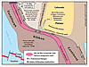 Figure 4
It is worth noting that the Laramide magmatic belt has exhumation ages of 70–50 Ma over its entire length (Miller and Morton, 1980; Wells and Hoisch, 2008; Miller et al., 2009; Armstrong, 1988) and that there are two bands of Laramide deformation: the better known band, mostly without proximal magmatism, located in the eastern Cordillera, and another with associated high-grade metamorphism and generally rapid exhumation located farther west in or adjacent to the magmatic belt. The deformation, magmatism, and exhumation are well known throughout the Transverse Ranges and Mojave Desert region of Southern California and Arizona (Haxel et al., 1984; May, 1989; Needy et al., 2009), as well as in the Cascades and Coast plutonic complex of British Columbia and the Yukon (Miller et al., 2009; Rusmore and Woodsworth, 1991; Parrish, 1992; Evenchik et al., 2007; Johnston and Canil, 2007).
Overall, the proposed reconstruction resolves many long-standing issues in Cordilleran geology and hints at solutions to many more. Not only are the paleomagnetic data accounted for, and the Baja-BC controversy resolved, but the currently dismembered Laramide magmatic, deformational, and metamorphic collisional belt is reunited and validates the reconstruction. Hopefully, this initial first-order model will lead others to work backward through time to better understand the development of the Cordilleran orogen. Many more surprises are yet to come.
Conclusions
- Similar relationships of well-dated and mapped units along both sides of the Lewis & Clark zone and the Texas Lineament suggest that the two features were formerly continuous.
- By restoring 1300 km of dextral slip along the Cordilleranfold-thrust belt—about the minimum indicated from paleomagnetic data—the Lewis & Clark transverse zone and the Texas Lineament are aligned into a continuous structure. The reconstruction is simple and clarifies many relationships that were previously difficult to explain.
- In the reconstruction (Fig. 4), the Laramide collision zone and its exhumed upper-plate slab-failure rocks occur in a continuous band from southern Mexico through the Transverse Ranges into the Cascades and Coast plutonic complex. Thus, there was no magmatic gap during the Laramide.
- Although they collided with North America in the Great Basin sector at about 125 Ma, the upper plate rocks accreted to
North America during the Sevier event migrated northward during the Laramide and, because the various terranes in the upper plate were amalgamated prior to the Laramide event (Hildebrand, 2013), now span nearly the entire width of the Canadian Cordillera. - The Cordilleran fold-thrust belt, located in the eastern Cordillera from about Las Vegas northward, typically has no associated magmatism and is a Laramide transpressive feature accommodating the northward migration of rocks previously accreted to the Great Basin sector of the margin during the 125–110 Ma Sevier event.
- If the rapid northward migration of the Kula plate drove the Cordilleran block northward as many believe, then the model constrains the long-uncertain position of the Kula-Farallon spreading ridge (Engebretson et al., 1985) to have been at least 1300 km south of the current location of the Cordilleran block—about the latitude of La Paz, Mexico (Fig. 4).
- Some Eocene and younger rocks, such as those of the Columbia River Basalt Group, the Ancestral Cascades, and Siletzia, abut directly against the remaining south-facing margin, illustrating that the transform margin maintained a strong influence on the distribution of geological units for about 100 m.y.
Acknowledgments
Randy Enkin, Charlie Kerans, Dennis Kent, Eldridge Moores, and Charlie Roots read the first draft and suggested improvements. Robert Hatcher and Stephen Johnston critically reviewed the manuscript and made helpful comments. I dedicate this paper to the memory of Ted Irving.
REFERENCES CITED
- Armstrong, R.L., 1988, Mesozoic and early Cenozoic magmatic evolution of the Canadian Cordillera, in Clark, S.P., Burchfiel, B.C., and Suppe, J., eds., Processes in Continental Lithosphere Deformation: Geological Society of America Special Paper 218, p. 55–91.
- Armstrong, R.L., Taubeneck, W.H., and Hales, P.O., 1977, Rb-Sr and K-Ar geochronometry of Mesozoic granitic rocks and their Sr isotopic composition, Oregon, Washington, and Idaho: GSA Bulletin, v. 88, p. 397–411, doi: 10.1130/0016-7606(1977)88<397:RAKGOM>2.0.CO;2.
- Beck, M.E., Jr., 1991, Case for northward transport of Baja and coastal southern California: Paleomagnetic data, analysis, and alternatives: Geology, v. 19, p. 506–509, doi: 10.1130/0091-7613(1991)019<0506:CFNTOB>2.3.CO;2.
- Beck, M.E., Jr., and Noson, L., 1972, Anomalous paleolatitudes in Cretaceous granitic rocks: Nature. Physical Science, v. 235, p. 11–13, doi: 10.1038/physci235011a0.
- Beranek, L.P., and Mortensen, J.K., 2007, Investigating a Triassic overlap assemblage in Yukon: On-going field studies and preliminary detrital-zircon age data, in Emond, D.S., Lewis, L.L., and Weston, L.H., eds., Yukon Exploration and Geology 2006: Yukon Geological Survey, p. 83–92.
- Beranek, L.P., and Mortensen, J.K., 2011, The timing and provenance record of the Late Permian Klondike orogeny in northwestern Canada and arc-continent collision along western North America: Tectonics, v. 30, TC5017, doi: 10.1029/2010TC002849.
- Burchfiel, B.C., Cowan, D.S., and Davis, G.A., 1992, Tectonic overview of the Cordilleran orogen in the western U.S., in Burchfiel, B.C., Lipman, P.W., and Zoback, M.L., eds., The Cordilleran Orogen: Conterminous U.S.: Boulder, Colorado, Geological Society of America, Geology of North America, v. G-3, p. 407–480.
- Butler, R.F., Gehrels, G.E., and Kodama, K.P., 2001, A moderate translation alternative to the Baja British Columbia hypothesis: GSA Today, v. 11, p. 4–10, doi: 10.1130/1052-5173(2001)011<0004:AMTATT>2.0.CO;2.
- Catuneanu, O., Sweet, A.R., and Miall, A.D., 2000, Reciprocal stratigraphy of the Campanian–Paleocene Western Interior of North America: Sedimentary Geology, v. 134, p. 235–255, doi: 10.1016/S0037-0738(00)00045-2.
- Dickinson, W., and Snyder, W.S., 1978, Plate tectonics of the Laramide orogeny, in Matthews, V., III, ed., Laramide Folding Associated with Basement Block Faulting in the Western United States: Geological Society of America Memoir 151, p. 335–366.
- du Bray, E.A., and John, D.A., 2011, Petrologic, tectonic, and metallogenic evolution of the ancestral Cascades magmatic arc, Washington, Oregon, and northern California: Geosphere, v. 7, p. 1102–1133, doi: 10.1130/GES00669.1.
- Engebretson, D.C., Cox, A., and Gordon, R.G., 1985, Relative Motions between Oceanic and Continental Plates in the Pacific Basin: Geological Society of America Special Paper 206, 59 p.
- Enkin, R.J., 2006, Paleomagnetism and the case for Baja British Columbia, in Haggart, J.W., Enkin, R.J., and Monger, J.W.H., eds., Paleogeography of the North American Cordillera: Evidence for and against Large-Scale Displacements: St. John’s, Newfoundland, Geological Association of Canada Special Paper 46, p. 233–254.
- Enkin, R.J., Osadetz, K.G., Baker, J., and Kisilevsky, D., 2000, Orogenic remagnetizations in the Front Ranges and inner foothills of the southern Canadian Cordillera: Chemical harbinger and thermal handmaiden of Cordilleran deformation: GSA Bulletin, v. 112, p. 929–942, doi: 10.1130/0016-7606(2000)112<929:ORITFR>2.0.CO;2.
- Enkin, R.J., Johnston, S.T., Larson, K.P., and Baker, J., 2006a, Paleomagnetism of the 70 Ma Carmacks Group at Solitary Mountain, Yukon, confirms and extends controversial results: Further evidence for the Baja British Columbia model, in Haggart, J.W., Enkin, R.J., and Monger, J.W.H., eds., Paleogeography of the North American Cordillera: Evidence for and against Large-Scale Displacements: St. John’s, Newfoundland, Geological Association of Canada Special Paper 46, p. 221–232.
- Enkin, R.J., Mahoney, J.B., and Baker, J., 2006b, Paleomagnetic signature of the Silverquick/Powell Creek succession, south-central British Columbia: Reaffirmation of Late Cretaceous large-scale terrane translation, in Haggart, J.W., Enkin, R.J., and Monger, J.W.H., eds., Paleogeography of the North American Cordillera: Evidence for and against Large-Scale Displacements: St. John’s, Newfoundland, Geological Association of Canada Special Paper 46, p. 201–220.
- Evenchick, C.A., McMechan, M.E., McNicoll, V.J., and Carr, S.D., 2007, A synthesis of the Jurassic–Cretaceous tectonic evolution of the central and southeastern Canadian Cordillera: Exploring links across the orogen, in Sears, J.W., Harms, T.A., and Evenchick, C.A., eds., Whence the Mountains?: Inquiries into the Evolution of Orogenic Systems: A Volume in Honor of Raymond A. Price: Geological Society of America Special Paper 433, p. 117–145.
- Fleck, R.J., and Criss, R.E., 1985, Strontium and oxygen isotopic variations in Mesozoic and Tertiary plutons of central Idaho: Contributions to Mineralogy and Petrology, v. 90, p. 291–308, doi: 10.1007/BF00378269.
- Foster, D.A., Doughty, P.T., Kalakay, T.J., Fanning, C.M., Coyner, S., Grice, W.C., and Vogl, J., 2007, Kinematics and timing of exhumation of metamorphic core complexes along the Lewis and Clark fault zone, northern Rocky Mountains, USA, in Till, A.B., Roeske, S.M., Sample, J.C., and Foster, D.A., eds., Exhumation Associated with Continental Strike-Slip Fault Systems: Geological Society of America Special Paper 434, p. 207–232.
- Fuentes, F., DeCelles, P.G., and Constenius, K.N., 2012, Regional structure and kinematic history of the Cordilleran fold-thrust belt in northwestern Montana, USA: Geosphere, v. 8, p. 1104–1128, doi: 10.1130/GES00773.1.
- Gilmer, A.K., Kyle, J.R., Connelly, J.N., Mathur, R.D., and Henry, C.D., 2003, Extension of Laramide magmatism in southwestern North America into Trans-Pecos Texas: Geology, v. 31, p. 447–450, doi: 10.1130/0091-7613(2003)031<0447:EOLMIS>2.0.CO;2.
- Gladwin, K., and Johnston, S.T., 2006, Mid-Cretaceous pinning of accreted terranes to miogeoclinal assemblages in the northern Cordillera: Irreconcilable with paleomagnetic data, in Haggart, J.W., Enkin, R.J., and Monger, J.W.H., eds., Paleogeography of the North American Cordillera: Evidence for and against Large-Scale Displacements: St. John’s, Newfoundland, Geological Association of Canada Special Paper 46, p. 299–306.
- Glazner, A.F., Nielson, J.E., Howard, K.A., and Miller, D.M., 1986, Correlation of the Peach Springs Tuff, a large-volume Miocene ignimbrite sheet in California and Arizona: Geology, v. 14, p. 840–843, doi: 10.1130/0091-7613(1986)14<840:COTPST>2.0.CO;2.
- Haxel, G.B., Tosdal, R.M., May, D.J., and Wright, J.E., 1984, Latest Cretaceous and early Tertiary orogenesis in south-central Arizona: Thrust faulting, regional metamorphism, and granitic plutonism: GSA Bulletin, v. 95, p. 631–653, doi: 10.1130/0016-7606(1984)95<631:LCAETO>2.0.CO;2.
- Henry, C.D., and John, D.A., 2013, Magmatism, ash-flow tuffs, and calderas of the ignimbrite flareup in the western Nevada volcanic field, Great Basin, USA: Geosphere, v. 9, p. 951–1008, doi: 10.1130/GES00867.1.
- Hildebrand, R.S., 2009, Did Westward Subduction Cause Cretaceous–Tertiary Orogeny in the North American Cordillera?: Geological Society of America Special Paper 457, 71 p.
- Hildebrand, R.S., 2013, Mesozoic assembly of the North American Cordillera: Geological Society of America Special Paper 495, 162 p.
- Hildebrand, R.S., 2014, Geology, mantle tomography, and inclination corrected paleogeographic trajectories support westward subduction during Cretaceous orogenesis in the North American Cordillera: Hank Williams Volume: Geoscience Canada, v. 41, p. 207–224, doi: 10.12789/geocanj.2014.41.032.
- Hildebrand, R.S., and Whalen, J.B., 2014, Arc and slab-failure magmatism in Cordilleran batholiths II—The Cretaceous Peninsular Ranges batholith of Southern and Baja California: Paul Hoffman Volume: Geoscience Canada, v. 41, p. 399–458, doi: 10.12789/geocanj.2014.41.059.
- Housen, B.A., and Dorsey, R.J., 2005, Paleomagnetism and tectonic significance of Albian and Cenomanian turbidites, Ochoco Basin, Mitchell Inlier, central Oregon: Journal of Geophysical Research, v. 110, B07102, doi: 10.1029/2004JB003458.
- Humphreys, E., 2009, Relation of flat subduction to magmatism and deformation in the western United States, in Kay, S.M., Ramos, V.A., and Dickinson, W.R., eds., Backbone of the Americas: Shallow Subduction, Plateau Uplift, and Ridge and Terrane Collision: Geological Society of America Memoir 204, p. 85–98.
- Irving, E., 1979, Paleopoles and paleolatitudes of North America and speculations about displaced terrains: Canadian Journal of Earth Sciences, v. 16, p. 669–694, doi: 10.1139/e79-065.
- Irving, E., 1985, Whence British Columbia: Nature, v. 314, p. 673–674, doi: 10.1038/314673a0.
- Irving, E., Wynne, P.J., Thorkelson, D.J., and Schiarizza, P., 1996, Large (1000–4000 km) northward movements of tectonic domains in the northern Cordillera, 83 to 45 Ma: Journal of Geophysical Research, v. 101, p. 17,901–17,916, doi: 10.1029/96JB01181.
- Johnston, S.T., 2001, The great Alaskan terrane wreck: Oroclinal orogeny and reconciliation of paleomagnetic and geological data in the northern Cordillera: Earth and Planetary Science Letters, v. 193, p. 259–272, doi: 10.1016/S0012-821X(01)00516-7.
- Johnston, S.T., 2008, The Cordilleran ribbon continent of North America: Annual Review of Earth and Planetary Sciences, v. 36, p. 495–530, doi: 10.1146/annurev.earth.36.031207.124331.
- Johnston, S.T., and Canil, D., 2007, Crustal architecture of SW Yukon, northern Cordillera: Implications for crustal growth in a convergent margin orogen: Tectonics, v. 26, TC1006, doi: 10.1029/2006TC001950.
- Kent, D.V., and Irving, E., 2010, Influence of inclination error in sedimentary rocks on the Triassic and Jurassic apparent pole wander path for North America and implications for Cordilleran tectonics: Journal of Geophysical Research, v. 115, B10103, doi: 10.1029/2009JB007205.
- Kent, D.V., and Witte, W.K., 1993, Slow apparent polar wander for North America in the Late Triassic and large Colorado Plateau rotation: Tectonics, v. 12, p. 291–300, doi: 10.1029/92TC01966.
- Kerr, R.A., 1995, How far did the west wander?: Science, v. 268, p. 635–637, doi: 10.1126/science.268.5211.635.
- Kim, B., and Kodama, K.P., 2004, A compaction correction for the paleo-magnetism of the Nanaimo Group sedimentary rocks: Implications for the Baja British Columbia hypothesis: Journal of Geophysical Research, v. 109, B02102, doi: 10.1029/2003JB002696.
- King, P.B., 1969, The tectonics of North America—A discussion to accompany the Tectonic Map of North America: U.S. Geological Survey Professional Paper 628, scale 1:5,000,000, 95 p.
- Mac Niocaill, C., Torsvik, T.H., and van der Pluijm, B., eds., 2003, Paleo-magnetism Applied to Tectonics—A Tribute to Rob Van der Voo: Tectonophysics Special Issue, v. 362, 355 p.
- Mahoney, J.B., Mustard, S., Haggart, J.W., Friedman, R.M., Fanning, M., and McNicholl, J., 1999, Archean and Proterozoic zircons in Cretaceous sediments of the western Canadian and northwest U.S. Cordillera: The “Baja-B.C.” hypothesis fails a “crucial test”: Geology, v. 27, p. 195–198, doi: 10.1130/0091-7613(1999)027<0195:AZICSO>2.3.CO;2.
- Manduca, C.A., Kuntz, M.A., and Silver, L.T., 1993, Emplacement and deformation history of the western margin of the Idaho batholith near McCall, Idaho: Influence of a major terrane boundary: GSA Bulletin, v. 105, p. 749–765, doi: 10.1130/0016-7606(1993)105<0749:EADHOT>2.3.CO;2.
- May, D.J., 1989, Late Cretaceous intra-arc thrusting in southern California: Tectonics, v. 8, p. 1159–1173, doi: 10.1029/TC008i006p01159.
- Mickus, K., Stern, R.J., Keller, G.R., and Anthony, E.Y., 2009, Potential field evidence for a volcanic rifted margin along the Texas Gulf Coast: Geology, v. 37, p. 387–390, doi: 10.1130/G25465A.1.
- Miller, F.K., and Morton, D.M., 1980, Potassium-Argon geochronology of the eastern Transverse Ranges and southern Mojave Desert, Southern California: U.S. Geological Survey Professional Paper 1152, 30 p.
- Miller, I.M., Brandon, M.T., and Hickey, L.J., 2006, Using leaf-margin analysis to estimate the mid-Cretaceous (Albian) paleolatitude of the Baja British Columbia block: Earth and Planetary Science Letters, v. 245, p. 95–114, doi: 10.1016/j.epsl.2006.02.022.
- Miller, R.B., Gordon, S.M., Bowring, S.A., Doran, B.A., McLean, N.M., Michels, Z.D., Shea, E.K., Whitney, D.L., Wintzer, N.E., and Mendoza, M.K., 2009, Linking deep and shallow crustal processes in an exhumed continental arc, North Cascades, Washington, in O’Connor, J.E., Dorsey, R.J., and Madin, I.P., eds., Volcanoes to Vineyards: Geologic Field Trips through the Dynamic Landscape of the Pacific Northwest: Geological Society of America Field Guide 15, p. 373–406.
- Mustard, P.S., 1994, The Upper Cretaceous Nanaimo Group, Georgia Basin, in Monger, J.W.H., ed., Geological Hazards of the Vancouver Region, Southwestern British Columbia: Geological Survey of Canada Bulletin 481, p. 27–96.
- Needy, S.K., Anderson, J.L., Wooden, J.L., Fleck, R.J., Barth, A.P., Paterson, S.R., Memeti, V., and Pignotta, G.S., 2009, Mesozoic magmatism in an upper- to middle-crustal section through the Cordilleran continental margin arc, eastern Transverse Ranges, California, in Miller, R.B., and Snoke, A.W., eds., Crustal Cross Sections from the Western North American Cordillera and Elsewhere: Implications for Tectonic and Petrologic Processes: Geological Society of America Special Paper 456, p. 187–218.
- Nelson, J.A., Colpron, M., and Israel, S., 2013, The Cordillera of British Columbia, Yukon, and Alaska: Tectonics and Metallogeny: Society of Economic Geologists Special Publication, v. 17, p. 53–109.
- Parrish, R.R., 1992, U-Pb ages for Cretaceous plutons in the eastern Coast Belt, Southern British Columbia, in Radiogenic Age and Isotopic Studies; Report 5: Geological Survey of Canada, Paper 91-2, p. 109–113.
- Rasmussen, K.L., 2013, The timing, composition and petrogenesis of syn- to post-accretionary magmatism in the northern Cordilleran miogeocline, eastern Yukon and southwestern Northwest Territories [unpub. Ph.D. dissertation]: Vancouver, University of British Columbia, 788 p.
- Reed, J.C., Wheeler, J.O., and Tucholke, B.E., compilers, 2004, Geologic map of North America: Decade of North American Geology Continental Scale Map 001, Boulder, Colorado, Geological Society of America, scale 1:5,000,000.
- Reidel, S.P., Camp, V.E., Tolan, T.L., and Martin, B.S., 2013, The Columbia River flood basalt province: Stratigraphy, areal extent, volume, and physical volcanology, in Reidel, S.P., Camp, V.E., Ross, M.E., Wolff, J.A., Martin, B.S., Tolan, T.L, and Wells, R.E., eds., The Columbia River Flood Basalt Province: Geological Society of America Special Paper 497, p. 1–43.
- Roberts, L.N.R., and Kirschbaum, M.A., 1995, Paleogeography of the Late Cretaceous of the Western Interior of middle North America—Coal distribution and sediment accumulation: U.S. Geological Survey Professional Paper 1561, 155 p.
- Rowan, M.G., Peel, F.J., and Vendeville, B.C., 2004, Gravity-driven fold belts on passive margins, in McClay, K.R., ed., Thrust tectonics and hydrocarbon systems: AAPG Memoir 82, p. 157–182.
- Rusmore, M.E., and Woodsworth, G.J., 1991, Coast Plutonic Complex: A mid-Cretaceous contractional orogen: Geology, v. 19, p. 941–944, doi: 10.1130/0091-7613(1991)019<0941:CPCAMC>2.3.CO;2.
- Sears, J.W., 1988, Two major thrust slabs in the west-central Montana Cordillera, in Schmidt, C.J., and Perry, W.J., Jr., eds., Interaction of the Rocky Mountain Foreland and the Cordilleran Thrust Belt: Geological Society of America Memoir 171, p. 165–170.
- Sears, J.W., 2007, Belt-Purcell basin: Keystone of the Rocky Mountain fold-and-thrust belt, United States and Canada, in Sears, J.W., Harms, T.A., and Evenchick, C.A., eds., Whence the Mountains?: Inquiries into the Evolution of Orogenic Systems: A Volume in Honor of Raymond A. Price: Geological Society of America Special Paper 433, p. 147–166.
- Sigloch, K., and Mihalynuk, M.G., 2013, Intra-oceanic subduction shaped the assembly of Cordilleran North America: Nature, v. 496, p. 50–56, doi: 10.1038/nature12019.
- Umhoefer, P.J., 1987, Northward translation of “Baja British Columbia” along the Late Cretaceous to Paleocene margin of western North America: Tectonics, v. 6, p. 377–394, doi: 10.1029/TC006i004p00377.
- Umhoefer, P.J., and Blakey, R.C., 2006, Moderate (1600 km) northward translation of Baja British Columbia from southern California and implications for western North America: An attempt at reconciliation of paleomagnetism and geology, in Haggart, J.W., Enkin, R.J., and Monger, J.W.H., eds., Paleogeography of the North American Cordillera: Evidence for and against Large-Scale Displacements: Geological Association of Canada Special Paper 46, p. 307–329.
- Umhoefer, P.J., Schiarizza, P., and Robinson, M., 2002, Relay Mountain Group, Tyaughton–Methow basin, southwest British Columbia: A major Middle Jurassic to Early Cretaceous terrane overlap assemblage: Canadian Journal of Earth Sciences, v. 39, p. 1143–1167, doi: 10.1139/e02-031.
- Unruh, D.M., Lund, K., Snee, L.W., and Kuntz, M.A., 2008, Uranium-lead zircon ages and Sr, Nd, and Pb isotope geochemistry of selected plutonic rocks from western Idaho: U.S. Geological Survey Open File Report 2008-1142, 42 p.
- Wallace, C.A., Lidke, D.J., and Schmidt, R.G., 1990, Faults of the central part of the Lewis and Clark line and fragmentation of the Late Cretaceous foreland basin in west-central Montana: GSA Bulletin, v. 102, p. 1021–1037, doi: 10.1130/0016-7606(1990)102<1021:FOTCPO>2.3.CO;2.
- Wells, M.L., and Hoisch, T.D., 2008, The role of mantle delamination in widespread Late Cretaceous extension and magmatism in the Cordilleran orogen, western United States: GSA Bulletin, v. 120, p. 515–530, doi: 10.1130/B26006.1.
- Wells, R., Bukry, D., Friedman, R., Pyle, D., Duncan, R., Haeussler, P., and Wooden, J., 2014, Geologic history of Siletzia, a large igneous province in the Oregon and Washington Coast Range: Correlation to the geomagnetic polarity time scale and implications for a long-lived Yellowstone hotspot: Geosphere, v. 10, p. 692–719, doi: 10.1130/GES01018.1.