
Page 5 - i1052-5173-31-1
P. 5
HOTSPOT CHRONOLOGY magmatic provinces are aligned with the propagates from beneath oceanic lithosphere,
We have compiled volcanic fields previ- proposed hotspot track and have a monotonic across continental lithosphere of accreted ter-
ously interpreted to be related to Yellowstone age progression similar to, but not identical ranes, to its current position beneath the North
hotspot magmatism across the northwestern to the model, which we will return to later. American craton.
U.S. on Figure 1, including a reconstructed Here we describe a history of progressive
Siletzia in the Eocene, in an attempt to docu- crustal melting manifested in the series of Volcanism and Accretion
ment the magmatic progression across the aligned tectonomagmatic stages in Figure of Siletzia (ca. 56–49 Ma)
forearc and through the Cascadia backarc 1B, ranging from rifting and oceanic-island- and Establishment of a New
region. Also plotted are the locations of the basalt–like (OIB) lavas in the forearc, to ada- Subduction System (ca. 48–45 Ma)
hotspot at 40.5 Ma from McCrory and kitic backarc magmatism, voluminous flood Radiometric ages constrained by field
Wilson (2013) and a proposed hotspot track basalt, and rhyolitic volcanism. These events, mapping, global nannoplankton zones, and
using the plate motions of Matthews et al. we suggest, record the progressive effects paleomagnetic correlations demonstrate that
(2016) and assuming a fixed hotspot. The of a long-lived Yellowstone hotspot as it Siletzia was formed from 56 to 49 Ma and
A
B
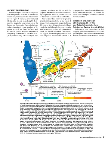
Figure 1. (A) Evolution of the Yellowstone hotspot (YHS) track relative to the North American plate. Siletzia is restored to
its relative position at ca. 42 Ma when the YHS was overridden by the accreted Siletzia terrane, now part of North Amer-
ica. Ancestral Cascades arc location at ca. 40 Ma is modified from Wells and McCaffrey (2013). Colored locations east of
Siletzia correspond to progressive sites of crustal melting along the hotspot track since ca. 30 Ma, without removal of
Basin and Range extension. Purple diamond and circle are locations of YHS with respect to N. America at 40.5 Ma from
McCrory and Wilson (2013) in Pacific (PAC) and Atlantic (ATL) hotspot frames; red dots are projected YHS locations using
plate motion of Matthews et al. (2016) and assuming a fixed YHS. Black and gray dotted lines are possible YHS tracks
modified from Wells et al. (2014). NNR—northern Nevada rift; YSRP—Yellowstone–Snake River Plain. Calderas, felsic
volcanic fields, and lava centers from Shervais and Hanan (2008), Benson et al. (2017), and Anders et al. (2019), with colors
corresponding to color-code ages in panel B. Mafic fields in the Coast Range: T—Tillamook; Y—Yachats; G—Grays River.
Felsic volcanic fields: LOVF—Lake Owyhee Volcanic Field; MVF—McDermitt Volcanic Field; HRCC—Field of the High
Rock Caldera Complex; OP-BJ-TF—Owyhee Plateau–Bruneau Jarbidge–Twin Falls Volcanic Field. Individual calderas
shown in irregular oval polygons: MR—Magic Reservoir; OH—Owyhee-Humboldt; BJ—Bruneau-Jarbidge caldera;
TF—Twin Falls caldera; R—Rooster Comb caldera; CR—caldera at Castle Rock; DM—Dooley Mountain; JM—Juniper
Mountain. Contemporaneous felsic centers shown as yellow boxes: SC—Silver City; LJ—Little Juniper Mountain;
HH—Horsehead Mountain; JB—Jackass Butte; SW—Swamp Creek Rhyolite; TMC—Twenty Mile Creek Rhyolite;
BB—Bald Butte; D—Drum Hill; HV—Hawks Valley–Lone Mountain; S—Sleeper Rhyolite; SR—Santa Rosa–Calico;
IN—Inzenhood; IV—Ivanhoe; J—Jarbidge. The two stars represent alternative sites for the plume center at 17–16 Ma, the
blue-star location supported by some workers (e.g., Glen and Ponce, 2002; Shervais and Hanan, 2008; Wolff and Ramos,
2013), and the red-star location supported by others (e.g., Camp and Ross, 2004; Pierce and Morgan, 2009; Benson et al.,
2017). (B) Timeline of tectonomagmatic events along the YHS track.
www.geosociety.org/gsatoday 5