
Page 6 - gt1509
P. 6
MILL CREEK DOME Table 1. Modal composition of gneisses from Mill Creek dome
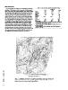
On aeromagnetic maps of the area around Baltimore (Bromery 1715* Sample no. 1716§
and others, 1964; Bromery, 1967; I. Zietz and J.R. Kirby, unpub. 1718†
data), some of the northernmost Baltimore Gneiss domes coincide
with distinctive deep magnetic lows. This is also true for some of Quartz 25.0 30.0 12.4
the gneiss domes in southeastern Pennsylvania (I. Zietz and J.R.
Kirby, unpub. data). In southeastern Pennsylvania and north- Microcline 46.9 33.7 –
western Delaware, near the common border of these states with
Maryland, aeromagnetic maps (Henderson and others, 1963; Oligoclase 23.2 30.9 33.3
Fig. 2, this paper) show a large magnetic low, similar in style and
intensity to the lows associated with some of the gneiss domes Biotite 4.6 5.2 0.6
near Baltimore. Some geologic maps of this area (Bascom and
Miller, 1920; Bascom and Stose, 1932; Gray and others, 1960) Hornblende – – 50.5
show discontinuous outcrop areas of marble (Bascom and Stose
and Gray and others called it Cockeysville Marble) coinciding Opaques trace trace 1.2
with the gradient on the edges of the magnetic low. No Setters
Formation rocks are shown in this area on any of the maps. On all Garnet – – 2.0
the maps except Bascom and Miller’s (1920), the rocks that coin-
cide with the main part of the magnetic low are shown as Accessories 0.3 0.2 trace
Total 100.0 100.0 100.0
Points counted 501 501 510
*Layered biotite-quartz-feldspar migmatite, Pennsylvania State Rte. 82,
305 m (1,000 ft) north of Delaware state line.
†Layered biotite-quartz-feldspar migmatite, Pennsylvania State Rte. 82,
at Delaware state line.
§Garnet amphibolite, Delaware State Rte. 82, 46 m (150 ft) south of
Pennsylvania state line.
GSA TODAY | SEPTEMBER 2015 Figure 2. Aeromagnetic map of part of southeastern Pennsylvania, northwestern Delaware, and
northeastern Maryland. Deep magnetic low (patterned) approximately outlines Mill Creek dome of
Baltimore Gneiss, Setters Formation, and Cockeysville Marble.
6