
Page 44 - i1052-5173-27-6
P. 44
The High Plains Aquifer: Can We Make It Last?
Susan Stover and Rex Buchanan, Kansas Geological Survey, University of Kansas, 1930 Constant Ave., Lawrence, Kansas 66047, USA
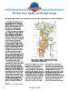
Nearly a third of the United States’ irri- Figure 1. Water level changes in the High Plains aquifer from pre-
gated crops depend on one massive but development (about 1950) to 2013, with primary area of declines
dwindling water source: the High Plains circled. Modified from McGuire (2014).
aquifer. Declining water levels in the High
Plains aquifer and responses to those improving its knowledge of its current and However, both states accept regional
declines are resource challenges that projected future conditions, information groundwater declines, allowing more use
necessitate input from geoscientists. essential for its sound management. to get the economic benefits of the aquifer,
a management approach sometimes called
The High Plains aquifer, which underlies In Kansas, Colorado, and Texas, states “planned depletion.” Texas governs
parts of eight states from South Dakota to with large aquifer declines, regulators gave groundwater by the rule of capture, which
Texas, consists of several interconnected irrigators the right to pump far more water gives landowners the right to use ground-
aquifers, including the Ogallala aquifer. than the aquifer can sustain. In Kansas and water beneath their property. Local
Unequally distributed, most of the southern Colorado, water right permits are governed groundwater conservation districts manage
two-thirds is in serious decline; water levels by seniority. When there is not enough water the High Plains aquifer in Texas, and most
have dropped >150 ft since pre-development to meet the needs of all water right holders, districts require well meters and annual
in areas of Texas and Kansas (Fig. 1; priority is given to those who own the water use reports from well owners.
McGuire, 2014). Roughly 19.6 million oldest, most senior rights, a system sum- Because water rights have legal standing,
acre-feet were pumped in 2005, primarily marized as “first in time, first in right.”
for irrigation (McGuire, 2009), a quantity
that exceeds the basin-wide average annual
inflow of the Colorado River (Bureau of
Reclamation, 2011). In 2013, three times
more water was pumped from the aquifer
in Kansas than the estimated natural
recharge rate (Buchanan et al., 2015).
Kansas warns that without changes, “70%
of the aquifer [in Kansas] will be depleted
within 50 years” (Kansas Water Office and
Kansas Department of Agriculture, 2015).
Water quality also impairs the aquifer in
some regions (Whittemore, 2012).
The High Plains aquifer is the source for
a highly productive region of corn, alfalfa,
soybeans, wheat, sorghum, and cotton
(Cruse et al., 2016). Crops support the
numerous cattle feedlots and large dairies
that overlie the High Plains aquifer. Meat-
packing, milk processing, ethanol plants,
and domestic users also rely on the aquifer.
It supports the region’s economy and the
U.S. food supply. Can the aquifer’s use be
slowed and its life extended? The aquifer’s
availability to future generations depends
on decisions by policy makers, water
managers, and especially irrigators. The
geoscience community is continually
GSA Today, v. 27, doi: 10.1130/GSATG318GW.1 GSA Today | June 2017
44