
Page 59 - i1052-5173-27-9
P. 59
A 93° W
30° N Chenier Plain Mississippi Delta New Orleans
20 km Wax Lake Delta
Subsidence rate (mm yr-1) Atchafalaya Delta
6 7 8 9 10 11 12
Semivariance (mm2yr-2) 80 C D
B 50 100 50 km 50 km
Distance (km) Kriging std. dev. (mm yr-1) Data std. dev. (mm yr-1)
60 0 4 8 12 16 20
40 0 4 8 12 16 20
20 150
00
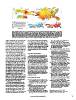
Figure 1. (A) Subsidence map for coastal Louisiana based on geostatistical interpolation (kriging) of 274 observations
(black dots) of land-surface subsidence rates over the past 6–10 years. Areas in white and gray are agricultural and
urban, respectively, and located outside of the wetlands. (B) Semivariogram of the data using 100 draws from different
kriging options (gray), the data mean (black), and the kriging model (red). (C) Uncertainty (standard deviation) of the
kriging estimate. Black squares show GPS stations. (D) Uncertainty (standard deviation) of the underlying data. Black
squares show National Oceanic and Atmospheric Administration (NOAA) tide gauges. Note that the subsidence map
can easily be converted into a relative sea-level rise map by adding the climate-driven sea-level component.
shallow compaction rates are known to be mm yrí that have been used in predictions ogy, v. 24, p. 76–99, doi:10.1306/D4269661-
highly sensitive to overburden loading. for the Mississippi Delta throughout the 21st 2B26-11D7-8648000102C1865D.
The high subsidence rates in coastal century (Blum and Roberts, 2009; Kim et Jankowski, K.L., Törnqvist, T.E., and Fernandes,
Louisiana likely mostly reflect natural pro- al., 2009) are in fact reflecting the conditions A.M., 2017, Vulnerability of Louisiana’s coastal
cesses that have operated over the past mil- that exist in coastal Louisiana today. Perhaps wetlands to present-day rates of relative sea-level
lennia. Despite the associated high rates of worst case scenarios should be considered rise: Nature Communications, v. 8, 14792,
RSLR, the abundant sediment supplied by the new normal in other LECZs worldwide doi:10.1038/ncomms14792.
the Mississippi River allowed its delta to as well. Jones, C.E., An, K., Blom, R.G., Kent, J.D., Ivins,
evolve into one of the world’s largest. E.R., and Bekaert, D., 2016, Anthropogenic and
ACKNOWLEDGMENTS geologic influences on subsidence in the vicinity
The new subsidence map should be con- of New Orleans, Louisiana: Journal of
sidered a first step; substantial efforts are This study would not have been possible with- Geophysical Research, Solid Earth, v. 121,
needed to refine this analysis. For example, out funding from the Coastal Wetland Planning, p. 3867–3887, doi:10.1002/2015JB012636.
our findings are not relevant for embanked Protection, and Restoration Act (CWPPRA) Karegar, M.A., Dixon, T.H., and Malservisi, R.,
urban settings with artificial drainage and Program and the State of Louisiana to support the 2015, A three-dimensional surface velocity field
localized groundwater extraction (Jones et Coastwide Reference Monitoring System (CRMS). for the Mississippi Delta: Implications for
al., 2016), most notably the New Orleans The Coastal Protection and Restoration Authority coastal restoration and flood potential: Geology,
metropolitan area, as well as the agricul- of Louisiana and the United States Geological v. 43, p. 519–522, doi:10.1130/G36598.1.
tural land that occupies well-drained allu- Survey jointly implement the CRMS Program on Kim, W., Mohrig, D., Twilley, R., Paola, C., and
vial ridges. We omitted these areas from behalf of CWPPRA. Funding for this study was Parker, G., 2009, Is it feasible to build new land
our subsidence map. Other caveats include also provided by the National Science Foundation in the Mississippi River Delta?: Eos, v. 90,
the possibility of underestimated rates in (EAR-1349311), the National Institute for Climatic p. 373–374, doi:10.1029/2009EO420001.
the birdfoot delta around the mouth of the Change Research Coastal Center of the Department Kolker, A.S., Allison, M.A., and Hameed, S., 2011,
Mississippi River, which is known to of Energy, and The Water Institute of the Gulf. An evaluation of subsidence rates and sea-level
exhibit anomalously high subsidence rates We would like to thank Marc Bierkens for his variability in the northern Gulf of Mexico:
(Fisk et al., 1954). We also cannot rule out advice on spatial interpolation. We appreciate the Geophysical Research Letters, v. 38, L21404,
that active growth faults and hydrocarbon constructive comments from Luigi Tosi and an doi:10.1029/2011GL049458.
extraction may locally cause higher rates anonymous reviewer. Strozzi, T., Teatini, P., Tosi, L., Wegmüller, U., and
not captured by the GPS stations. Werner, C., 2013, Land subsidence of natural
REFERENCES CITED transitional environments by satellite radar
Our newly calculated present-day sub- interferometry on artificial reflectors: Journal of
sidence rates are considerably higher than Blum, M.D., and Roberts, H.H., 2009, Drowning Geophysical Research, Earth Surface, v. 118,
what has been reported by recent studies of the Mississippi Delta due to insufficient sedi- p. 1177–1191, doi:10.1002/jgrf.20082.
that relied partly or entirely on tide gauges ment supply and global sea-level rise: Nature Wolstencroft, M., Shen, Z., Törnqvist, T.E., Milne,
and that inferred rates of 1–6 mm yrí for Geoscience, v. 2, p. 488–491, doi:10.1038/ G.A., and Kulp, M., 2014, Understanding
the past few decades (Kolker et al., 2011; ngeo553. subsidence in the Mississippi Delta region due to
Karegar et al., 2015). As a result, “worst case sediment, ice, and ocean loading: Insights from
scenarios” with subsidence rates of 8–10 Cahoon, D.R., 2015, Estimating relative sea-level geophysical modeling: Journal of Geophysical
rise and submergence potential at a coastal Research, Solid Earth, v. 119, p. 3838–3856,
wetland: Estuaries and Coasts, v. 38, p. 1077– doi:10.1002/2013JB010928.
1084, doi:10.1007/s12237-014-9872-8.
MANUSCRIPT RECEIVED 23 MAR. 2017
Fisk, H.N., Kolb, C.R., McFarlan, E., and Wilbert, REVISED MANUSCRIPT RECEIVED 15 MAY 2017
L.J., 1954, Sedimentary framework of the modern MANUSCRIPT ACCEPTED 16 MAY 2017
Mississippi delta: Journal of Sedimentary Petrol-
www.geosociety.org/gsatoday 59