
Page 7 - i1052-5173-28-7
P. 7
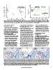
Figure 3. Results of Geoprobe coring to determine dip of strath surface. (A) Elevation of strath surface at each coring site as a function of distance
upstream from the mouth of the Wisconsin River. Trendline (blue dashed line) represents original strath surface, dipping to the east with an estimated
slope of 0.15 m/km; asl—above sea level. (B) Bridgeport strath surface as resolved from Geoprobe coring (eastward-dipping blue dashed line) in relation
to other major (westward-dipping) surfaces in the lower Wisconsin River valley; modified from Knox and Attig (1988).

Geomorphology of the Lower                    primary evidence of reversal of flow on        control, river valleys broaden in the
Wisconsin River Valley                        the mainstem stream (e.g., Chamberlin          downstream direction. The narrowing in
                                              and Leverett, 1894, p. 265).                   the downstream direction exhibited in
  Transformative events to the landscape    2.	The curve of the valley wall at the inside    the lower Wisconsin River valley lends
should—and often do—leave indications         of the confluence of the modern                additional credence to the argument for
of previous conditions, and the geomor-       Mississippi and Wisconsin Rivers (i.e.,        a valley that was incised by an eastward-
phology of the lower Wisconsin River val-     to the immediate northeast; solid orange       flowing river and subsequently reversed.
ley contains several indications of having    in Fig. 1C) is inconsistent with having
been formed by an eastward-flowing river      been incised as the confluence of two        Geomorphology of the Upper
(Fig. 4). They are as follows:                rivers. Rather than coming to a point as     Mississippi River
1. 	The lower Wisconsin River valley,         would be expected at the confluence of
                                              streams in a dendritic system, the valley      In addition to the lower Wisconsin
  between the modern confluence with the      wall is a smooth curved radius. It is con-   River displaying geomorphic features that
  Mississippi River and the MIS 2 glacial     sistent with being at the inside of a tight  reflect a major reorganization, the
  margin, has a large number of barbed        bend of a single river; numerous similar     Mississippi River also contains a hallmark
  tributaries—valleys that join the lower     forms can be found along the insides of      feature of stream piracy. The reach of the
  Wisconsin River valley angling to the       curves along the upper Mississippi and       Mississippi River valley immediately
  east, as would be expected if they          lower Wisconsin Rivers.                      south of its confluence with the Wisconsin
  formed over time as tributaries to an     3. 	The lower Wisconsin River valley nar-      River is distinctly narrow with short, steep
  eastward-flowing river (blue arrows in      rows incongruously from east to west.        tributaries (yellow bracket in Fig. 1C). The
  Fig. 1C). Lacking an overriding struc-      Lacking overriding bedrock geologic          dissimilarity of these tributaries to other
  tural control, the presence of barbed                                                    valleys throughout the region is so
  tributary valleys has long been held as

Figure 4. Proposed time series for the common processes that drove stream piracy and reorganization of pre-Quaternary drainage patterns in the
North American mid-continent to create the modern Ohio (MO) and upper Mississippi (UM) Rivers. (A) Proposed configuration of the ancestral Wyalus-
ing (W), Teays (T), and Pittsburgh (P) Rivers as they evolved prior to Quaternary glaciations. Red dashed line represents the approximate location of the
continental drainage divide. (B) Damming of the lower St. Lawrence drainage by early to middle Quaternary glaciation(s) blocked the ancestral Wyalus-
ing River to create the informally named glacial Lake Muscoda (GLMu); the ancestral Teays River to create glacial Lake Tight (GLT); and the ancestral
Pittsburgh River to create glacial Lake Monongahela (GLMo). Spill-over of the lakes at the lowest drainage divides (red diamonds) initiated reorganiza-
tion of river systems. (C) Modern drainage configuration, with continental drainage divide (red dashed line) moved northward as drainage capture
diverted river systems away from the Gulf of St. Lawrence and toward the Gulf of Mexico. UO—upper Ohio River.

                                            www.geosociety.org/gsatoday                                                                                    7