
Page 52 - visitorGuide
P. 52
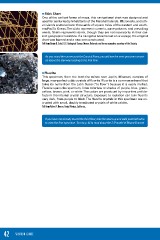
■ Stick Chart
                                       One of the earliest forms of maps, this navigational chart was designed and
                                       used for centuries by inhabitants of the Marshall Islands, Micronesia, and oth-
                                       er islands scattered over thousands of square miles of the western and south-
                                       ern Pacific Ocean.The sticks represent currents, wave patterns, and prevailing
                                       winds. Shells represent islands, though they are not necessarily in their cor-
                                       rect geographic locations. If a navigator became lost on a voyage, the original
                                       chart was burned and a new one constructed.
                                       Gift from Edwin B. Eckel, U.S. Geological Survey, Denver, Colorado, and former executive secretary of the Society.

                                          As you round the corner past the Council Room, you will see the next specimen mount-
                                          ed above the stairway leading to the first floor.

                                    ■ Fluorite
                                       This specimen, from the lead-zinc mines near Joplin, Missouri, consists of
                                       large, near-perfect cubic crystals of fluorite. Fluorite is a common mineral that
                                       takes its name from the Latin fluere (“to flow”) because it is easily melted.
                                       Fluorite spans the spectrum, from colorless to shades of purple, blue, green,
                                       yellow, brown, pink, or white. The colors are produced by impurities and de-
                                       fects in the internal crystal structure. Exposure to radiation can turn fluorite
                                       very dark, from purple to black. The fluorite crystals in this specimen are en-
                                       crusted with small, doubly terminated crystals of white calcite.
                                       Gift from Robert F. Herron, Santa Monica, California.

                                          If you have not already toured the third floor, take the stairs up and walk past both atria
                                          to view the first specimen. Turn to p. 45 to read about the 3-D model of Mount Everest.

42 VISITOR GUIDE