
Page 55 - visitorGuide
P. 55
Third Floor Exhibits
■ Orthophoto Map of Mount Everest
Opposite the 3-D model is an orthophoto map of Mount Everest’s northwest
face.This map is based on a photo taken at 13,500 m (44,300 ft) on 22 Decem-
ber 1984 from a Learjet photo-mapping flight sponsored by Boston’s Museum
of Science and the National Geographic Society.The process of orthophotog-
raphy corrects the normal distortion found in vertical images of rough, moun-
tainous country so that the photo can be precisely fitted to an accurate map.
This permits accurate plotting of both geologic details and climbing routes.
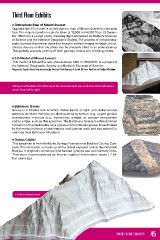
■ 3-D Model of Mount Everest
This model of Mount Everest, shown above 7900 m (26,000 ft), is a project of
the National Geographic Society and Boston’s Museum of Science.
Prepared by Sigurds Rauda from contouring by Swissair Photo Surveys of Zurich. Gift from Bradford and Barbara Washburn.
Taking an immediate left at the top of the stairs will lead you to shelves lined with speci-
mens. From left to right:
■ Baltimore Gneiss
Gneiss is a foliated rock in which thicker bands of light- and darker-colored
minerals alternate. Varieties are distinguished by texture (e.g., augen gneiss),
characteristic minerals (e.g., hornblende gneiss), or general composition
and/or origin, such as this specimen.The Baltimore Gneiss is a Precambrian
formation of banded biotite mica gneiss and hornblende gneiss. It was formed
by the metamorphosis of sedimentary and igneous rocks and was named for
outcrops near Baltimore, Maryland.
■ Gneiss Cobble
This specimen is from the Idaho Springs Formation in Boulder County, Colo-
rado. This formation is made up of the oldest exposed rock in the Colorado
Rockies. It originally contained interbedded igneous and sedimentary rocks.
They were metamorphosed by intense regional deformation about 1.7 bil-
lion years ago.
3-D Model of Mount Everest
45THIRD FLOOR EXHIBITS