
Page 5 - i1052-5173-31-10+AR
P. 5
BR RM 35 Rio Grande
rift
CP
105 125 125 125 125 125 125 5
105
85
RGR 85
GP Mogollon Datil
Figure 1 volcanic field 105 40
105
33°N BR 30 transitionn n Great Plains
ra
ra
r
a
i
si
t
o
tio
s
ns
a
n
si
si
zo
on
z
zone
e
e
n
n
GPS profile
in Fig. 2
28
New Mexico
New Mexico
105
105
Arizona 35
Arizona
Basin and
Range
32°N 30
T exas
Texas
Boot Heel ? ? ? ?
volcanic field
?
?
?
?
?
?
?
?
?
?
?
? ?
30
Quaternary fault 1 mm/yr; 90% Chihuahua
Chihuahua
confidence ellipse
31°N Quaternary basalt flow Reflection/refraction line N
Miocene - Quaternary basin fill
Cenozoic volcanic rocks 37-23 Ma calderas
28
Paleozoic - Mesozoic rocks Magnetotelluric station
Proterozoic rocks 0 Bulk crustal conductance (seimens)
1000
2000
500
1500
Thermochronology sample 0 15 30 60 90 120
(AHe, ZHe, and/or AFT) km
109°W 108°W 107°W 106°W 105°W
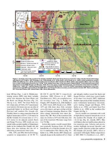
Figure 1. Geologic map of the southern Rio Grande rift (RGR)–Basin and Range Province transition. Map includes thermochronology
data (Kelley and Chapin, 1997; Ricketts et al., 2016; Biddle et al., 2018; Gavel, 2019; Reade et al., 2020), global positioning system
(GPS) data (Murray et al., 2019), reflection/refraction line (Averill, 2007; Averill and Miller, 2013), and magnetotelluric data recording
bulk crustal conductance (Feucht et al., 2019). Thick dashed black line is the boundary of Mack (2004). Cross-hatched areas show
deep basins of the RGR (Seager and Morgan, 1979). Blue lines show crustal thickness (km), and white lines show heat flow (mWm )
–2
(Keller et al., 1990). AFT—apatite fission-track; AHe—apatite (U-Th)/He; ZHe—zircon (U-Th)/He. Inset shows metamorphic core com-
plexes in blue and different models for the RGR–Basin and Range Province boundary, as discussed in the text. BR—Basin and Range;
CP—Colorado Plateau; GP—Great Plains; RM—Rocky Mountains.
least 100 km (Figs. 1 and 2). Global posi- 60–120 °C, and 50–240 °C, respectively and abruptly shallow toward the Basin and
tioning system (GPS) data show variable (Ketcham, 2005; Flowers et al., 2009; Range Province, which have typical depths
strain rates between the Great Plains and Guenthner et al., 2013), are compiled across of less than 1 km (Averill, 2007). Additional
the Basin and Range Province (Fig. 2A; the transition zone (Fig. 1; Kelley and shallow expressions of this boundary include
Murray et al., 2019). The Great Plains has Chapin, 1997; Ricketts et al., 2016; Biddle et more voluminous Quaternary volcanism,
low strain rates of 0.68 ± 0.17 nanostrains/ al., 2018; Gavel, 2019; Reade et al., 2020). active faulting (Seager and Morgan, 1979;
year (nstr/yr), but strain rates are an order of AFT and AHe dates show little variation Keller et al., 1990), and higher heat flow
magnitude higher in the Basin and Range across this region, and ages overlap with the (Keller et al., 1990) in the southern Rio
Province and southern Rio Grande rift. time of Cenozoic extension. However, ZHe Grande rift (Fig. 1).
Notably, there is a sharp transition from the dates change drastically over short dis- Gravity models are consistent with a welt
highest strain rates of 8.54 ± 2.10 nstr/yr in tances (Fig. 2B). West of the transition ZHe of high-density material beneath the axis of
the Rio Grande rift to lower rates of 1.45 ± dates are similar to AFT and AHe dates, but the southern Rio Grande rift at depths of
0.31 nstr/yr in the adjacent eastern Basin east of the transition ZHe dates range from ~12–21 km (Fig. 2C; Averill, 2007). This
and Range Province. GPS results are con- 2 to 731 Ma. welt thins to the west and becomes absent in
sistent with a greater number of Quaternary Across this region, overall crustal thick- the transition zone. Velocity and gravity
faults in the southern Rio Grande rift, but ness gradually increases from ~28–30 km models highlight decreased densities and
these data also indicate that the rift is beneath the axis of the Rio Grande rift to 35 upper mantle velocities within the southern
deforming at interseismic time scales. km in southwestern New Mexico (Fig. 2C; Rio Grande rift (Averill, 2007), which is
AHe, AFT, and ZHe thermochronology, Keller et al., 1990; Averill, 2007). Basins are associated with higher Moho temperatures
sensitive to temperatures of 30–90 °C, typically deeper in the southern rift (2–4 km) of 900–1000 °C (Hamblock et al., 2007).
www.geosociety.org/gsatoday 5