
Page 21 - i1052-5173-31-8
P. 21
At 32 years of age, Owen was appointed as a U.S. geologist by new home of the Smithsonian Institution. Owen proposed the distinc-
Congress in July 1839 to conduct a survey of Iowa, Wisconsin, tive red-brown Seneca Creek Sandstone as the building material for
and northern Illinois. He assembled a team to discharge the survey, the Smithsonian, which came to fruition with the completion of the
calling upon the assistance of John Locke and Ebenezer Phillips. Smithsonian castle in 1855.
The geological report summarizing his work was published as U.S.
House Executive Document No. 239 on 2 April 1840. A follow-up LEGACY
report that included 25 plates of hand-drawn illustrations and maps In 1847, Owen was once again appointed by the U.S. Congress
was published as Senate Executive Document No. 407 on 11 July to expand his geological investigation of the mineral lands of
1844. This latter report showcased Owen’s artistic talents of sketch- Illinois, Iowa, and Wisconsin to include Minnesota and parts of
ing landscapes and fossils, as well as establishing a systematic way Nebraska. He assembled a team of geologists to conduct this work
to summarize a geological survey. under his supervision, including John Evans, Fielding B. Meek,
Joseph G. Norwood, Richard Owen, Benjamin Shumard, Charles
Whittlesey, and Amos H. Worthen. For this work, Owen trained
and educated most of these geologists in New Harmony, who later
led state and federal surveys of their own.
In 1852, the report generated by Owen standardized the format for
federal geologic reports, including the narrative, maps, plates, and
illustrations. This report also used several new reproduction tech-
niques, including metal-ruled on steel and Daguerreotypes to illus-
trate fossils. Ultimately, this work provided a foundation for the forth-
coming railroad surveys of the western United States in the 1860s and
1870s and the establishment of the U.S. Geological Survey in 1879.
After his role as U.S. geologist ended in 1854, Owen assumed
the role of state geologist of Kentucky from 1854 to 1857; state
geologist of Arkansas from 1857 to 1859; and returned as Indiana
state geologist from 1859 to 1860. In October 1860, Owen was
diagnosed with acute rheumatism and was confined to his sleep-
ing chamber. Instead of resting, Owen continued toward comple-
tion of his second geological report of Arkansas. To accomplish
this task, he dictated to two persons from his bedside. His col-
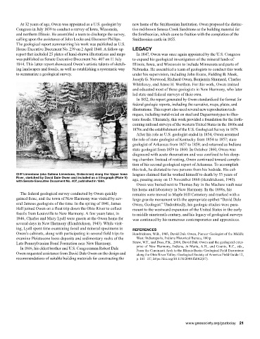
Cliff Limestone (aka Galena Limestone, Ordovician) along the Upper Iowa leagues claimed that he worked himself to death by 53 years of
River, sketched by David Dale Owen and included as a lithograph (Plate V) age, passing away on 13 November 1860 (Hendrickson, 1943).
with Senate Executive Document No. 407, published in 1844.
Owen was buried next to Thomas Say in the Maclure vault near
his home and laboratory in New Harmony. In the 1890s, his
The federal geological survey conducted by Owen quickly remains were moved to Maple Hill Cemetery and marked with a
gained fame, and the town of New Harmony was visited by sev- large granite monument with the appropriate epithet “David Dale
eral famous geologists of the time. In the spring of 1841, James Owen, Geologist.” Undoubtedly, his geologic studies were para-
Hall joined Owen on a float trip down the Ohio River to collect mount to the westward expansion of the United States in the early
fossils from Louisville to New Harmony. A few years later, in to middle nineteenth century, and his legacy of geological surveys
1846, Charles and Mary Lyell were guests at the Owen home for was continued by his numerous contemporaries and apprentices.
several days in New Harmony (Hendrickson, 1943). While visit-
ing, Lyell spent time examining fossil and mineral specimens in REFERENCES
Owen’s cabinets, along with participating in several field trips to Hendrickson, W.B., 1943, David Dale Owen, Pioneer Geologist of the Middle
examine Pleistocene loess deposits and sedimentary rocks of the West: Indianapolis, Indiana Historical Bureau, 180 p.
Late Pennsylvanian Bond Formation near New Harmony. Straw, W.T., and Doss, P.K., 2008, David Dale Owen and the geological enter-
In 1846, his eldest brother and U.S. Congressman Robert Dale prise of New Harmony, Indiana, in Maria, A.H., and Counts, R.C., eds.,
Owen requested assistance from David Dale Owen on the design and From the Cincinnati Arch to the Illinois Basin: Geological Field Excursions
along the Ohio River Valley: Geological Society of America Field Guide 12,
recommendations of suitable building materials for constructing the p. 105–117, https://doi.org/10.1130/2008.fld012(07).
www.geosociety.org/gsatoday 21