
Page 5 - i1052-5173-31-9
P. 5
multiple constellations (i.e., GPS, Glonass,
Galileo, and BeiDou), now permit model
geo-registration with greater simplicity and
accuracies that are acceptable for many geo-
scientific applications. Most current smart-
phones are equipped with such GNSS chip-
sets, which enable the positioning of photos
and GCPs with meter-level accuracy, or even
spatial-decimeter accuracy for dual-fre-
quency chipsets, with >20 min acquisition
times for individual locations (Dabove et al.,
2020; Uradziński and Bakuła, 2020). Under
these conditions, the use of smartphones per-
mits georeferencing of >~100-m-wide pho-
togrammetric models generated via terres-
trial imagery (Fig. 1). The availability of
photo orientation information, provided by Figure 1. Scale-ranges of applicability of different methods for the registration of 3D models of out-
crops, and tools used in this work. GCPs—ground control points; GNSS—global navigation satellite
the smartphone’s inertial measurement unit system; RTK—real-time kinematic.
(especially the magnetometer and gyro-
scope/accelerometer sensors), in conjunction
with the GNSS position, can further improve
the quality of the model registration proce-
dure. Indeed, the photo orientation informa-
tion mitigates the positional error associated
with the Z component, and full georeferenc-
ing of >50–60-m-wide exposures can be
achieved with a consumer-grade dual-fre-
quency GNSS chipset–equipped smartphone
(Tavani et al., 2019, 2020).
Confident georeferencing of smaller-scale
outcrops with minimal equipment, however,
remains challenging, limiting the utility of
photogrammetric acquisition in routine geo-
logical fieldwork. In this article, we present a
workflow using a smartphone and minimal
accessories to address this challenge (Fig. 1)
and demonstrate the applicability of using
smartphone photo and video surveys of an
active fault in the Apennines (Italy). Those
3D models are georeferenced by integrating
the use of Agisoft Metashape and OpenPlot
software tools (Tavani et al., 2019).
METHODS AND DATA
The Acquisition Site
The survey method proposed herein was
performed on an outcrop of an active nor-
mal fault located within the Apennines,
central Italy. A high-resolution 3D surface
reconstruction of the outcrop is already
available (Corradetti et al., 2021), thus
allowing us to compare our results with a
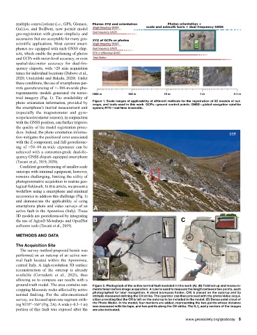
ground-truth model. The area contains out- Figure 2. Photograph of the active normal fault modeled in this work (A). (B) Field set up and measure-
cropping Mesozoic rocks affected by active ments taken before image acquisition. A ruler is used to measure the length between two points, each
normal faulting. For the aforementioned photographed for later recognition. A stand (compass holder, CH) is placed on the outcrop and its
attitude measured defining the CH strike. The operator can then proceed with the photo/video acqui-
survey, we focused upon one segment strik- sition providing that the CH is left on the outcrop to be included in the model. (C) Dense point cloud of
ing N135°–160° (Fig. 2A). A wide (~0.3–1 m) the Photo Model. In the model, four markers are added, representing the two points whose distance
was measured with the tape, and two points along the CH strike. The θ, ξ, and ρ vectors of the images
portion of this fault was exposed after the are also indicated.
www.geosociety.org/gsatoday 5