
Page 28 - i1052-5173-27-3-4
P. 28
Zealandia: Earth’s Hidden Continent
Nick Mortimer, GNS Science, Private Bag 1930, Dunedin 9054, New Zealand; Hamish J. Campbell, GNS Science, P.O. Box 30368,
Lower Hutt 5040, New Zealand; Andy J. Tulloch, GNS Science, Private Bag 1930, Dunedin 9054, New Zealand; Peter R. King, Vaughan
M. Stagpoole, Ray A. Wood, Mark S. Rattenbury, GNS Science, P.O. Box 30368, Lower Hutt 5040, New Zealand; Rupert Sutherland,
SGEES, Victoria University of Wellington, P.O. Box 600, Wellington 6140, New Zealand; Chris J. Adams, GNS Science, Private Bag 1930,
Dunedin 9054, New Zealand; Julien Collot, Service Géologique de Nouvelle Calédonie, B.P. 465, Nouméa 98845, New Caledonia; and
Maria Seton, School of Geosciences, University of Sydney, NSW 2006, Australia
ABSTRACT in which to investigate processes of conti- continental fragments that were stranded
nental rifting, thinning, and breakup. in the ocean basins during supercontinent
A 4.9 Mkm2 region of the southwest breakups (e.g., Buck, 1991; Lister et al.,
Pacific Ocean is made up of continental INTRODUCTION 1991; Gaina et al., 2003; Franke, 2013;
crust. The region has elevated bathymetry Eagles et al., 2015). But what about the
relative to surrounding oceanic crust, Earth’s surface is divided into two types major continents (Fig. 1)? Continents are
diverse and silica-rich rocks, and rela- of crust, continental and oceanic, and into Earth’s largest surficial solid objects, and it
tively thick and low-velocity crustal struc- 14 major tectonic plates (Fig. 1; Holmes, seems unlikely that a new one could ever
ture. Its isolation from Australia and large 1965; Bird, 2003). In combination, these be proposed.
area support its definition as a conti- divisions provide a powerful descriptive
nent—Zealandia. Zealandia was formerly framework in which to understand and The Glossary of Geology defines a con-
part of Gondwana. Today it is 94% sub- investigate Earth’s history and processes. tinent as “one of the Earth’s major land
merged, mainly as a result of widespread In the past 50 years there has been great masses, including both dry land and conti-
Late Cretaceous crustal thinning preced- emphasis and progress in measuring and nental shelves” (Neuendorf et al., 2005).
ing supercontinent breakup and conse- modeling aspects of plate tectonics at It is generally agreed that continents have
quent isostatic balance. The identification various scales (e.g., Kearey et al., 2009). all the following attributes: (1) high eleva-
of Zealandia as a geological continent, Simultaneously, there have been advances tion relative to regions floored by oceanic
rather than a collection of continental in our understanding of continental rifting, crust; (2) a broad range of siliceous igne-
islands, fragments, and slices, more cor- continent-ocean boundaries (COBs), and ous, metamorphic, and sedimentary rocks;
rectly represents the geology of this part the discovery of a number of micro- (3) thicker crust and lower seismic velocity
of Earth. Zealandia provides a fresh context
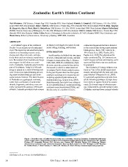
Figure 1. Simplified map of Earth’s tectonic plates and continents, including Zealandia. Continental shelf areas
shown in pale colors. Large igneous province (LIP) submarine plateaus shown by blue dashed lines: AP—Agulhas
Plateau; KP—Kerguelen Plateau; OJP—Ontong Java Plateau; MP—Manihiki Plateau; HP—Hikurangi Plateau.
Selected microcontinents and continental fragments shown by black dotted lines: Md—Madagascar; Mt—Mauritia;
D—Gulden Draak; T—East Tasman; G—Gilbert; B—Bollons; O—South Orkney. Hammer equal area projection.
GSA Today, v. 27, no. 3–4, doi: 10.1130/GSATG321A.1
28 GSA Today | March–April 2017