
Page 31 - i1052-5173-27-3-4
P. 31
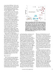
mean density of 2830 kgm-3 with an aver-      Figure 4. Areas and submergence of all of Earth’s geological con-
age thickness of 46 km for orogens and 30     tinents (red symbols) along with microcontinents (brown symbols)
km for extended crust. In contrast, oceanic   and intraoceanic large igneous provinces (LIPs, blue symbols)
crust is typically 7 km thick, and, in its    shown in Figures 1 and 2. Note x-axis is log scale. Data mainly
lower part typically has a P wave velocity    after Cogley (1984) except Zealandia data from Mortimer and
of 7.5 km-1 (White et al., 1992).             Campbell (2014); microcontinents after Gaina et al. (2003) and
                                              Torsvik et al. (2013). Emergent land area for Antarctica is the iso-
  From geophysical work, we know that         statically-corrected ice-free bedrock surface from Jamieson et al.
Zealandia has a continental crust velocity    (2014). New Guinea and Greenland are arbitrarily given the same
structure, Vp, generally <7.0 km-1, and a     submergence value as their parent continents. AP—Agulhas
thickness typically ranging from 10 to        Plateau; KP—Kerguelen Plateau; OJP—Ontong Java Plateau;
30 km throughout its entire extent to         MP—Manihiki Plateau; HP—Hikurangi Plateau; N Am—North
>40 km under parts of South Island (Shor      America; S Am—South America.
et al., 1971; Klingelhoefer et al., 2007;
Grobys et al., 2008; Eberhart-Phillips et     continental geology is continuous across       Mauritia, and Gulden Draak microconti-
al., 2010; Segev et al., 2012). Whereas most  Nares Strait between northernmost              nents (Gaina et al., 2003; Torsvik et al.,
of Zealandia’s crust is thinner than the      Greenland and Ellesmere Island                 2013; Whittaker et al., 2016). Discriminating
30–46 km that is typical of most conti-       (Pulvertaft and Dawes, 2011). Tectonic         between what is a continent and what is a
nents, the above studies show that it is      plate boundaries, with or without interven-    microcontinent may be considered an arbi-
everywhere thicker than the ~7-km-thick       ing oceanic crust, provide the basis for       trary exercise. Nonetheless, maps like
crust of the ocean basins. This result is     continent-continent boundaries between         Figure 1 need labels. Therefore, following
visible in the global CRUST1.0 model of       Africa and Eurasia, and North and South        Cogley (1984) and the vagaries of general
Laske et al. (2013) shown in Figure 3.        America (Fig. 1). Large area is an inherent    conventional usage, we propose that the
Collectively, the crustal structure results   part of the definition of a continent sensu    name continent be applied to regions of
show that the rock samples of Figure 2 are    stricto (Neuendorf et al., 2005). Cogley       continental crust that are >1 Mkm2 in area
not from separate continental fragments or    (1984) defined Central America (1.3 Mkm2),     and are bounded by well-defined geologic
blocks now separated by oceanic crust, but    Arabia (4.6 Mkm2), and greater India           limits. By this definition India, prior to its
are from a single continental mass.           (4.6 Mkm2) as modern-day continents.           collision with Eurasia, would be termed a
                                              This schema has not been generally             continent.
  The thinnest crust within Zealandia is in   adopted, probably because Central
the 2200-km-long and 200–300-km-wide          America (the Chortis block) is a piece of        The edges of Australia and Zealandia
New Caledonia Trough, where the water         displaced North America, and Arabia and        continental crust approach to within 25 km
depth varies from 1500 to 3500 m (Fig. 2).    India are transferring to, and are now         across the Cato Trough (Fig. 2). The Cato
This raises the question as to whether the    contiguous with, Eurasia and have clearly      Trough is 3600 m deep and floored by oce-
trough is floored by oceanic crust or is a    defined COBs in the Red Sea and Indian         anic crust (Gaina et al., 1998; Exon et al.,
failed continental rift. Two wide-angle       Ocean (Fig. 1). The six commonly recog-        2006). The Australian and Zealandian
seismic profiles across the trough near       nized geological continents (Africa,           COBs here coincide with, and have been
New Caledonia (Klingelhoefer et al., 2007)    Eurasia, North America, South America,         created by, the Cato Fracture Zone along
both show ~2–5 km of sedimentary cover        Antarctica, and Australia) are thus not only   which there has been ~150 km of dextral
over 8.5 km of crustal basement that has a    large but they are also spatially isolated by  strike slip movement, linking Paleogene
velocity of ~7 km-1 throughout much of its    geologic and/or bathymetric features.          spreading centers in the Tasman and Coral
thickness. Klingelhoefer et al. (2007) noted                                                 seas (Fig. 2; Gaina et al., 1998). This spatial
these profiles as atypical of normal oce-       At the other end of the size spectrum, a     and tectonic separation, along with inter-
anic crust. Sutherland et al. (2010) and      number of continental crust fragments in       vening oceanic crust, means that the
Hackney et al. (2012) interpreted the New     the world’s oceans are referred to as          Zealandia continental crust is physically
Caledonia Trough as continental crust that    microcontinents. Examples include the          separate from that of Australia. If the Cato
was thinned in the Late Cretaceous and        Madagascar, East Tasman, Jan Mayen,            Trough did not exist, then the content of this
re-deepened in the Eocene due to litho-
sphere delamination.

Limits and Area

  Where oceanic crust abuts continental
crust, various kinds of continent-ocean
boundaries (COBs) define natural edges to
continents (Fig. 1; Eagles et al., 2015).
Despite its large area, Greenland is uncon-
troversially and correctly regarded as part
of North America (Figs. 1 and 4). This is
because, despite oceanic crust intervening
between southern Greenland and Labrador
and Baffin Island, North American

                                              www.geosociety.org/gsatoday                                                                     31