
Page 29 - i1052-5173-27-3-4
P. 29
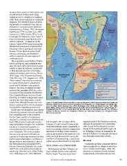
structure than oceanic crustal regions; and Figure 2. Spatial limits of Zealandia. Base map from Stagpoole (2002) based on data from Smith and
(4) well-defined limits around a large Sandwell (1997). Continental basement samples from Suggate et al. (1978), Beggs et al. (1990), Tull-
enough area to be considered a continent och et al. (1991, 2009), Gamble et al. (1993), McDougall et al. (1994), and Mortimer et al. (1997, 1998,
rather than a microcontinent or continental 2006, 2008a, 2008b, 2015). NC—New Caledonia; WTP—West Torres Plateau; CT—Cato Trough; Cf—
fragment. The first three points are defin- Chesterfield Islands; L—Lord Howe Island; N—Norfolk Island; K—Kermadec Islands; Ch—Chatham
ing elements of continental crust and are Islands; B—Bounty Islands; An—Antipodes Islands; Au—Auckland Islands; Ca—Campbell Island.
explained in many geoscience textbooks Mercator projection.
and reviews (e.g., Holmes, 1965; Christensen
and Mooney, 1995; Levander et al., 2005; and Campbell, 2014; Graham, 2015). regarded as part of the Australian continent,
Kearey et al., 2009; Condie, 2015). To our However, it is still not well known to the although the geographic term Australasia
knowledge, the last point—how “major” a broad international science community. A often is used for the collective land and
piece of continental crust has to be to be correct accounting of Earth’s continents is islands of the southwest Pacific region. In
called a continent—is almost never dis- important for multiple fields of natural the following sections, we summarize the
cussed, Cogley (1984) being an exception. science; the purpose of this paper is to for- four key attributes of continents and assess
Perhaps this is because it is assumed that mally put forth the scientific case for the how Zealandia meets these criteria.
the names of the six geological continents— continent of Zealandia (Figs. 1 and 2) and
Eurasia, Africa, North America, South explain why its identification is important. Elevation
America, Antarctica, and Australia—
suffice to describe all major regions of ZEALANDIA AS A CONTINENT Continents and their continental shelves
continental crust. vary in height but are always elevated rela-
New Zealand and New Caledonia are tive to oceanic crust (Cogley, 1984). The
The progressive accumulation of bathy- large, isolated islands in the southwest elevation is a function of many features,
metric, geological, and geophysical data Pacific Ocean. They have never been fundamentally lithosphere density and
since the nineteenth century has led many
authors to apply the adjective continental
to New Zealand and some of its nearby
submarine plateaus and rises (e.g., Hector,
1895; Hayes, 1935; Thomson and Evison,
1962; Shor et al., 1971; Suggate et al., 1978).
“New Zealand” was listed as a continent
by Cogley (1984), but he noted that its
continental limits were very sparsely
mapped. The name Zealandia was first
proposed by Luyendyk (1995) as a collec-
tive name for New Zealand, the Chatham
Rise, Campbell Plateau, and Lord Howe
Rise (Fig. 2). Implicit in Luyendyk’s paper
was that this was a large region of conti-
nental crust, although this was only men-
tioned in passing and he did not character-
ize and define Zealandia as we do here.
In this paper we summarize and reassess
a variety of geoscience data sets and show
that a substantial part of the southwest
Pacific Ocean consists of a continuous
expanse of continental crust. Furthermore,
the 4.9 Mkm2 area of continental crust is
large and separate enough to be considered
not just as a continental fragment or a
microcontinent, but as an actual conti-
nent—Zealandia. This is not a sudden
discovery but a gradual realization; as
recently as 10 years ago we would not have
had the accumulated data or confidence in
interpretation to write this paper. Since it
was first proposed by Luyendyk (1995),
the use of the name Zealandia for a south-
west Pacific continent has had moderate
uptake (e.g., Mortimer et al., 2006; Grobys
et al., 2008; Segev et al., 2012; Mortimer
www.geosociety.org/gsatoday 29