
Page 7 - i1052-5173-27-5
P. 7
Cairo earthquake where water-saturated
silty to sandy soil had been shaken and
failed near the epicenter (El-Gamal et al.,
1993). Similar features at shallow depths in
the delta’s Holocene unconsolidated depos-
its near the coast (Fig. 4B), some of which
probably also failed by recent neotectonic
motion and liquefaction, are illustrated in
the following section.
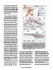
COMPACTION AND SUBSIDENCE Figure 3. (A) Recent earthquake epicenters in the Nile delta and northern
Egypt, emphasizing two active megashears discussed in text: (1) East Medi-
Sediment compaction rates are calcu- terranean-Cairo-Fayum Trend, and (2) Red Sea-Gulf of Suez-Alexandria Trend
lated for the Holocene sections in 85 drill (modified after Kebeasy, 1990, and Gamal, 2013). (B) The depocenter’s coastal
cores landward of the coast. Radiocarbon margin showing gas field discoveries and major structural trends both on-
dates in most cores provide a temporal and offshore, including the pronounced Neogene Hinge Zone trending E-W
framework for interpreting these sediment across the northern delta (after EGAS, 2015). G.O.S.—Gulf of Suez. (C) SE to
sections. Compaction rates were deter- NW cross section highlighting subsurface stratigraphy and major subsurface
mined by measuring the thicknesses of structural trends from delta to offshore shelf, including some that extend to
individual strata in each meter of drilled the delta surface (after Kellner et al., 2009).
Holocene deposits between the delta sur-
face and basal section at each core site so NW sector (I); ~7.7 mm/yr in the NC sec- depositional rates, including the Rosetta,
as to measure average thicknesses per tor (II); and ~8.4 mm/yr in the NE sector Baltim, and Damietta headlands (Fig. 2A).
meter and for the entire core at each site. (III). Measurement of upper strata com- To determine rates of relative sea level, ARC
A total of 3183 layers in cores were thus paction per meter provides results that par- measurements are added to those of eustatic
examined to determine if any systematic allel those of land subsidence measure- sea-level rise; these latter presently range
down-core temporal and spatial-regional ments made by recent satellite surveys from 2.6 to 3.3 mm/yr since ~2000 A.D.
thickness patterns in the northern delta (El-Asmar et al., 2012). For example, high (cf. Shaltout et al., 2015; Hansen et al., 2016).
could be detected (Stanley and Corwin, subsidence rates, to ~8 mm/yr, were mea- Of note, an average eustatic rise of 3 mm/yr
2013). Thickest layers are almost always sured for sectors between Baltim and would account for only ~26% to 45% of total
recorded in the top 1–2 m of section and Manzala lagoon (Becker and Sultan, relative sea-level rise rates between NE delta
dated to <1000 yr in age; the next few 2009). Satellite imagery techniques (radar sector III and NW delta sector I.
meters below this upper section record interferometry) identified coastal sectors
considerably thinner strata. This observa- of accelerated subsidence in areas of Measurement of sand, silt, and clay pro-
tion is attributed to expulsion of interstitial Holocene sections subject to high portions in Holocene core samples (Stanley
pore water by compression from sediment and Clemente, 2014) indicate that relative
overburden and by evaporation in near-
surface deposits in this arid setting (100–
250 mm rainfall/yr). Strata thicknesses
tend to decrease irregularly to depths of
5–6 m during the upper to mid-Holocene,
and from those depths downward they con-
tinue to thin more gradually from mid- to
basal Holocene sections. Strata thickness
reduction rates, calculated by derivatives
of regression curves, are treated as proxy
for compaction rate (Stanley and Corwin,
2013). By mid-core depths, >50% of total
Holocene core compaction is accounted for
by strata thickness reduction. These pat-
terns of down-core stratal thinning are
observed all along the northern delta plain
and prevail independently of original dep-
ositional environment and total thickness
of Holocene section.
This strata thickness method shows that
average rates of compaction (ARC) mea-
sured for total Holocene sections vary
regionally along the delta margin, increas-
ing as follows (Fig. 4A): ~3.7 mm/yr in
www.geosociety.org/gsatoday 7