
Page 8 - i1052-5173-27-5
P. 8
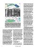
Figure 4. (A) Map showing distribution of average relative percentages of clay                  submergence by eustatic sea-level rise and
in Holocene sections and average rates of compaction (ARC) in mm/yr across                      land subsidence triggered by neotectonics
three northern delta sectors (I, II, III); dots indicate sites of 85 sampled drill              and/or sediment compaction as discussed
cores (after Stanley and Clemente, 2014). (B) X-radiographs of selected drill                   above. This balance no longer occurs suf-
cores sections (locations shown in A): horizontal laminations in S-47; fault-                   ficiently at the Nile delta’s coastal sector
like shears(s) in S-31 and S-59; and convoluted strata units in S-18 and S-59.                  where amounts of discharged water and
Scale = 2 cm. (C) Location of seven submerged sites with archaeological                         sediment have diminished markedly in
material; the 11 numbers indicate depths (in m) of materials below present                      recent time due to altered climatic condi-
sea level (after Stanley and Toscano, 2009). (D) Plotted age and depth of sub-                  tions and much increased human impacts.
merged materials in C show all lie well below the Eastern Mediterranean                         Without addition of much needed super-
sea-level curve of Sivan et al. (2001), recording continued margin subsidence.                  posed deposits at the coast, the youngest
                                                                                                (earlier than 1000 A.D.), uppermost
percentages of clay are highest (40%–60%)        layers generally occur between horizontal      water-saturated sediment layers are now
in the N and NE sectors (II, III) where high     strata above and below them, they likely       being lowered at a more rapid rate relative
ARC values range from 7.7 to 8.4 mm/yr           record the effects of natural episodic dis-    to sea level (Figs. 4C and 4D).
(Fig. 4A). This finer-grained sediment           turbance events. Some may have formed
fraction is preferentially displaced by cur-     by rapidly increased sediment accumula-          The Nile’s present total flow is contrib-
rents toward the NE delta margin (arrows         tion and overloading. Others perhaps           uted by relatively small, isolated areas in
in Fig. 5A). It is likely that water-saturated,  resulted from recent earthquake tremors        the East African lake region and the
clay-rich sediments readily expulsed much        and ground motion, or from tectonic shifts     Ethiopian highlands. The high precipita-
of their interstitial pore water shortly after   and reorganization of underlying strata at     tion at the headland of the White Nile is
burial by successive deposits and evapora-       depth, as cited in the previous section.       distributed between two rainfall seasons.
tion. In X-radiographs of Holocene delta         Similarly, human-triggered effects also        Water of the White Nile enters the Sudd
core sections, most displaying well-             occur in areas where delta surfaces have       marshes and seasonally flooded areas to
defined horizontal bedding (Fig. 4B, sec-        been artificially lowered to ~1 m or more      the north, where evaporation greatly
tion S-47), there are examples of interbed-      and that are affected locally by liquefaction  exceeds rainfall; this results in an outflow
ded strata that have been extensively            as a result of hydrocarbon and ground-         from the wetlands that is only about half
disturbed. Some display convolute stratifi-      water extraction.                              that of inflow (Sutcliffe and Parks, 1999).
cation (Fig. 4B, in sections S-18 and S-59),                                                    In marked contrast, the Ethiopian moun-
interpreted as having failed by liquefaction     DECREASED SEDIMENT                             tains, with their high rainfall in a single
and upward expulsion of interstitial water.      REPLENISHMENT                                  season and steep topography, produce
Other disturbed strata record sharp, fault-                                                     larger runoffs and more concentrated
like shear offsets (Fig. 4B, arrows and            An ample sediment supply provided            flows in the Blue Nile and Atbara during
symbol S in S-31 and S-59). Because such         regularly to a delta’s margin helps mini-      shorter periods.
                                                 mize or moderate problems of coastal
                                                                                                  During much of the Holocene, amounts
                                                                                                of sediment transported from upland Nile
                                                                                                sources and dispersed northward to the
                                                                                                delta margin have been largely controlled
                                                                                                by Nile hydrologic attributes responding to
                                                                                                major long-term climatic variations. Strong
                                                                                                rains prevailed, especially during the latest
                                                                                                Pleistocene-Holocene Wet Phase that, in
                                                                                                Ethiopia, lasted ~6500 yr, between ca.
                                                                                                9000 B.C. and ca. 2500 B.C. (Said, 1993,
                                                                                                his figure 2.12). The rain-front at that time
                                                                                                shifted northward 8–10 degrees in the Nile
                                                                                                Basin, over arid sectors of the Sahel and
                                                                                                sectors of the Sahara in the Sudan and
                                                                                                Egypt. Such rainfall patterns responded
                                                                                                largely to fluctuation of the Inter-Tropical
                                                                                                Convergence Zone (ITCZ) that induced
                                                                                                major Nilotic hydrologic and sedimenta-
                                                                                                tion changes due to low-latitude isolation
                                                                                                forcing over long periods. On a shorter
                                                                                                (sub-millennial) scale, Nile valley climatic
                                                                                                input by El Niño Southern Oscillations
                                                                                                (ENSO) were also influential (Said, 1993;
                                                                                                Marriner et al., 2012). During the African
                                                                                                humid phase, strong boreal summer insu-
                                                                                                lation produced higher rainfall in northern

8 GSA Today | May 2017