
Page 9 - i1052-5173-27-5
P. 9
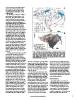
Africa, which led to important tributary       Figure 5. (A) Map of geographic features and network of major canals,
(wadi) input into the lower Main Nile          drains, and pumping stations in the Nile delta (modified after Sestini, 1992);
valley that accounted for 40%–50% of           arrows at coast show dominant east-directed wave-driven current flow
total fluvial water and much-increased         (after various authors). (B) Map of delta soil salinities (non-saline = <1000
sediment loads.                                ppm; moderate-mixed saline = 1000–35,000 ppm; highly saline = 35,000
                                               ppm), highlighting the southward progressing saline intrusion (modified
  The Wet Phase, ending at ca. 2500 B.C.,      after Sefelnasr and Sherif, 2014).
was followed to the present by an Arid
Phase (Said, 1993). Nile tributary input       55.5 Bm3 is reserved for Egypt. At present,    now releases less than 10% of its water
ceased, while the Main Nile received a         a large fraction of Nile sediment that once    supply, a mostly saline and highly polluted
larger proportion of Blue Nile and Atbara      accounted for ~100 million tons deposited      aqueous mix, to the sea, with little sediment
contributions. Ethiopian highlands pres-       below Aswan is now trapped in the south-       available for coastal replenishment. Egypt,
ently supply by far the largest proportions    ern part of the reservoir, where it has been   the tenth and last country below Nile head-
of Nile water (Blue Nile: 59%; Atbara          forming a new lacustrian delta since the       waters, presently needs much more fresh
River: 13%; Sobat: 14%) and sediment           High Dam closure.                              water than can be provided by the Main
transported northward across the Sudan                                                        Nile. Without it, the delta’s coastal margin,
and Egypt. The White Nile, flowing across        Several other large-scale projects under     for the most part depleted of its former sedi-
parts of eight countries (Fig. 1), provides    construction include those to divert large     ment supply for replenishment, continues to
only 28% of the total Nile water supply, of    volumes of Nile water to convert arid, saline  erode locally and subside.
which about half of this amount (14%) is       areas into agricultural land: one to bring
contributed by the Sobat, one of its tribu-    water from Lake Nasser to oases in Egypt’s     PROGNOSTICS
taries with a source in Ethiopia. The Blue     Western Desert (Toshka–New Valley
and White Niles and Atbara join to form        Project); another is to distribute water         A minimal relative sea-level rise of
the Main Nile in the Sudan (Woodward et        across the northern Sinai (Al-Salam Canal      ~100 cm is predicted between now and the
al., 2015), and this fluvial system then con-  Project). Moreover, dams and barrages have     year 2100 at the Nile delta’s coast, where
tinues in its channel that crosses desert      been built in the Sudan and Ethiopia. Most     laterally variable but continued ~6.7 to
terrains of both the Sudan and Egypt to the    of the now-limited volume of Nile water        ~11.4 mm/yr rates of submergence have
delta. North of the delta’s apex near Cairo,   that reaches the delta is diverted and chan-   been measured. This takes into account
most Nile waters are now diverted into a       nelized into the complex water distribution    average rates of sediment compaction
complex irrigation system comprising hun-      system, most utilized for agricultural,        leading to subsidence of ~3.7 to 8.4 mm/yr
dreds of kilometers of canals and drains       municipal, and industrial needs. Egypt         (NW to NE delta rates) added to the
(Fig. 5A).

  Anthropogenic pressures have increased
continuously, especially during the past
two centuries, and now dominate the
hydrographic system. Barrages (Assyut,
Naga Hamadi, Esna) emplaced on the Nile
during the nineteenth century, the first dam
at Aswan (Low Dam) in 1902, and water
diversion systems along the Nile valley had
already modified water delivery to lower
Egypt by the turn of the twentieth century.
Two mid-1900s dams in the northern delta,
one constructed at Edfina on the Nile’s
Rosetta branch and the other at Faraksour
Sudd on the Damietta branch, prevent
water in these two now much-altered dis-
tributaries from reaching the coast (Fig.
2A). The High Aswan Dam was then con-
structed in 1965 to release Nile water
throughout the year instead of during the
short flood season in summer. It is backed
by the enormous Lake Nasser reservoir
(area of 5250 km2; length of 510 km), with
a large water loss (12%–14% of annual
input) from evaporation and seepage.
Consequently, the total amount of water
flowing below the High Dam and to the
delta is considerably reduced. About 84 Bm3
of useable fresh water remain, of which

                                               www.geosociety.org/gsatoday                                                                    9