
Page 7 - gt1508
P. 7
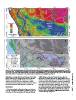
Figure 4. (A) LiDAR-derived digital elevation model (DEM) of the Blackwater National Wildlife Refuge projected with the NAD83 datum; produced by H. Pierce (2012,         GSA TODAY | www.geosociety.org/gsatoday
pers. comm.); m ASL—meters above sea level. Cell size is 2.5 m by 2.5 m; graduated elevation scale indicated to the left of the image exaggerates subtle features in the
lowest elevation ranges. White outline indicates boundary of the Blackwater National Wildlife Refuge. (B) Same LiDAR DEM as (A) in gray-scale with geomorphic
features referenced in the text superimposed. AD 1905 channel margins were digitized from the topographic map in Figure 3A.

initial Holocene transgression into the Blackwater River valley    Wildlife Refuge and the greater Chesapeake Bay region. The
by 5310–5570 cal yr B.P. Woody material within the silt, just      Pleistocene record and cosmogenic ages suggest that the onset of
below the peat boundary, is 690–910 cal yr B.P., setting a         Northern Hemisphere glaciation at the Plio-Pleistocene boundary
maximum age for marsh accretion. Radiocarbon samples               initiated cycles of incision and deposition. The paleo–Susquehanna
collected above this boundary and within the peat have modern      River and its tributaries responded to repeated ~50–100-m sea-level
ages (GSA Supplemental Data Table S3 [see footnote 1]).            fluctuations (Lisiecki and Raymo, 2005) with deep incision of
                                                                   river valleys during glacial lowstands and fluvio-estuarine deposi-
DISCUSSION                                                         tion during transgressions. Estuarine conditions prevailed during
                                                                   portions of MIS 3, when global proxies indicate that eustatic sea
  Fluctuating sea levels, resulting from changes in eustatic sea   level was ~40–80 m below present, suggesting prolonged relaxation
level, and crustal deformation (uplift and subsidence) related to  of a MIS 6 forebulge during MIS 3.
GIA, define the Pleistocene history of the Blackwater National

                                                                                                                                                                          7