
Page 5 - gt1063-4
P. 5
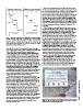
De nition by unit-stratotypes     De nition by boundary-stratotypes                    Since the time of Nicolas Steno, those who observed stratified
                                         L MN                                        rocks and considered the processes by which they formed accepted
WX  YZ                                                                               the concept that stratigraphic successions recorded the passage of
                                                                                     time. Present-day bodies of strata are distinguished from the
      Stage D                     Stage D                                            interval of time in the past when they accumulated as sediment by
      ? Gap                                    Stage C                               the use of two sets of terms. Chronostratigraphic terms apply to
                                                                                     rock units (system, series, and stage), and geochronologic terms
                 Stage C                                   Stage B                   apply to time units (period, epoch, and age). These differences in
                                                         Stage A                     terminology and concepts are presented in all stratigraphic guides
Overlap                                  Boundary-Stratotype                         and codes, even in first-year historical geology textbooks, and date
                                                                                     to the 2nd International Geologic Congress in Bologna in 1881
              Stage B                                                                (Vai, 2004).

                      ? Gap                                                            A GSSP defines a stratigraphic boundary between two succes-
                         Stage A                                                     sive chronostratigraphic units in a single, continuous stratigraphic
                                                                                     section. It sets the lower limit to the content of stratigraphic
         Unit-Stratotype                                                             signals in a designated unit; hence, the upper limit to the content
                                                                                     of the subjacent unit. The detailed succession of stratigraphic
Figure 1. Advantage of defining chronostratigraphic units (stages) by lower          signals through the boundary interval is the basis for interpreting           GSA TODAY | www.geosociety.org/gsatoday
boundary-stratotypes rather than by unit-stratotypes. Under boundary-                the correlation of that boundary into successions at other locali-
stratotypes a specific level (horizontal dashed line) within a stratotype section    ties. The correlation of boundaries between successions in
(solid vertical line) serves to define the base of the superjacent unit and the top  different localities is no different from correlating various strati-
of the subjacent unit. Capital letters refer to widely separated type localities.    graphic levels or intervals within a unit, except that a GSSP is pref-
Modified from Salvador (1994, their fig. 14).                                        erably placed at a stratigraphic level that provides the best set of
                                                                                     stratigraphic signals for worldwide correlation. Use of lower-
ratified by IUGS is the ICS International Chronostratigraphic                        boundary GSSPs results in a succession of units between which
Chart and the Table of GSSPs, which are linked to the publications                   there are no gaps and no overlaps (Fig. 1). A proposal for a GSSP is
of the ratified GSSP proposals (www.stratigraphy.org).                               evaluated on several criteria (Remane et al., 1996), with the most
                                                                                     important being that the boundary interval in the stratotype
  Most of the systems, series, and stages of the ICS International                   section has a diversity of stratigraphic signals that serve as the
Chronostratigraphic Chart were first defined from type sections or                   reference for the most reliable long distance correlation possible.
type areas in Europe, and they served as the basis for temporally
correlating stratified Phanerozoic rocks worldwide primarily on                        Since the first GSSP was ratified in 1972 for the boundary
their paleontological content. Although the traditional chronostrati-                between the Silurian and Devonian systems, 62 of the 100
graphic units were initially characterized by and correlated on the                  boundary levels that define the stages, series, and systems of the
biostratigraphy of macrofossils, the biostratigraphy of microfossils                 ICS Chart (download from www.stratigraphy.org) have ratified
became more widely used because they offered higher resolution and                   GSSPs. Most often, these sites are marked with an explanatory
more widespread correlation. More recently, records of magneto-                      panel, a formal plaque (Fig. 2), and a “golden spike” (Fig. 3).
stratigraphy, chemostratigraphy, cyclostratigraphy, and sequence
stratigraphy have been established for most units, thus adding more                  Figure 2. Plaque that marks the Global Standard Stratotype Section and Point
varied and global stratigraphic signals for correlation. Thus, the                   (GSSP) for the base of the Thanetian Stage (Paleocene Series, Paleogene
concept of chronostratigraphic units today is a composite of strati-                 System) at Zumaia, the Basque Region, Spain.
graphic information from successions worldwide.

  When the traditional units were first named, boundaries
between successive units were rarely defined. In fact, many units
in type areas are bounded above or below by unconformities or
covered intervals, and type areas of successive units are often at
different locations. With continued study in type areas, with the
study of stratigraphic successions elsewhere, and with the
increased resolution of long-distance correlation, many successive
chronostratigraphic units were discovered to either overlap or
to be separated by gaps (Fig. 1). Furthermore, because of paleo-
ecological and paleogeographical limits to the fossil content on
which the units were recognized and because of the lack of
specific boundaries, different interpretations of the stratigraphic
extent and status were accorded to the same unit from one
region to another, and multiple sets of regional series and stages
were established for many systems (e.g., Webby, 1998). These
deficiencies complicated stratigraphic nomenclature and
hindered communication.

                                                                                                                                                                   5