
Page 6 - gt1063-4
P. 6
Placement of Publication of
marker proposal
If ratified
IUGS Executive Committee
If ≥60% majority yes vote
ICS Bureau: ICS Executive + all Subcommission Chairs
If ≥60% majority yes vote
GSA TODAY | MARCH/APRIL 2016 Figure 3. Top of golden spike emplaced in bed that is the Global Standard Subcommission
Stratotype Section and Point (GSSP) for the Thanetian Stage. Length of “rock
hammer” is 5 cm. Working Group
They are regarded as international geostandards, and their protec- GSSP Proposal: section and point
tion and future scientific study are encouraged. Each one serves as
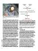
the primary definition of a boundary, which is the succession of Figure 4. Workflow for approval and ratification of a Global Standard
stratigraphic signals in a boundary interval and the single signal at Stratotype Section and Point (GSSP) proposal. Extensive discussion and
the stratigraphic level at which the boundary is placed. Locating evaluation occurs at the level of the working group, subcommission, and
the boundary in stratigraphic successions elsewhere is an interpre- International Commission on Stratigraphy (ICS) Bureau. If approved at these
tation made to the standard reference, the GSSP, after evaluation successive levels, a proposal is forwarded to the International Union of
of all stratigraphic signals. The formal process of ratification of a Geological Sciences (IUGS) for ratification. This process is also followed for
GSSP (Fig. 4) begins with preparation of a written proposal by a other ICS decisions on standardization, such as approval of names of formal
working group comprised of specialists on the boundary interval. units, of revisions to the units, and to revision or replacement of GSSPs.
Development of a formal proposal requires extensive investiga-
tions of candidate stratotype sections and boundary levels world- stratigraphic level in a stratotype section, that defines the boundary
wide. Following consensus approval of a proposal by the working and to which numerical ages are calibrated to varying degrees
group, it is then considered by the voting members of the relevant of certainty.
ICS subcommission. If approved by the subcommission, the
proposal is forwarded to the ICS executive for consideration and THE ANTHROPOCENE
voting by the ICS executive and the chairs of the 16 subcommis-
sions. If approved at this level, the proposal is forwarded to the The term Anthropocene is widely used. In its latest iteration, it
IUGS Executive Committee for ratification. Following ratifica- refers to the present, when human impact on Earth’s surface, atmo-
tion, the GSSP proposal must be published and posted on the ICS sphere, and hydrosphere has been deemed to be global. International
website, and the GSSP must be marked. The rigorous criteria on organizations; national, regional, and local governments; non-
which a GSSP proposal is evaluated and the several levels of evalu- governmental organizations; and industries have taken steps to
ation and consideration by which it is approved and ratified give mitigate and remediate the impact where its nature is judged to be
validity and authority to ratified GSSPs as international deleterious. Nevertheless, human impact is immense and potentially
geostandards. increasing. But, the question is: Should the Anthropocene be
approved by the ICS and ratified by the IUGS as an official unit of
A geochronologic unit (period, epoch, age) is the time interval the ICS International Chronostratigraphic Chart?
during which the strata of a chronostratigraphic unit accumulated
(Salvador, 1994). Geologic and biologic events and settings of the STRATIGRAPHIC RECORD OF THE ANTHROPOCENE
past, recorded in and interpreted from the rock record, are
expressed in terms of geochronologic units. Once two successive In contrast to all other units of the ICS chart, the concept of
GSSPs have been ratified, all the rocks that can be correlated to the Anthropocene did not derive from the stratigraphic record.
levels between the GSSPs are the stratigraphic record from which It arose with Paul Crutzen (2002), a Nobel Laureate in Chemistry,
past events in Earth’s history are interpreted for that interval of who suggested that because of a greatly increased human impact
time. Geochronologic terms yield a relative geologic time scale, on the Earth system, we had entered a new epoch, for which he
and calibrated ages make up a numerical geologic time scale. proposed the term Anthropocene. Zalasiewicz et al. (2008)
Calibrated numerical ages do not define the boundaries; they are considered the effects referred to by Crutzen and raised the ques-
subject to refinement and recalibration. It is the GSSP, a specific tion of whether the effects justified the need for a new term, and
if so, where and how its boundary might be placed. The ICS
Subcommission on Quaternary Stratigraphy established a
6