Page 21 - i1052-5173-27-2
P. 21

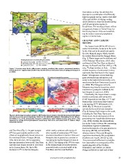
MWoeisstteurrley                GobiLDimesietrotmf moiosntusroeonal                                                             Hemisphere cooling. We attribute this
                                                                                                                                decrease to a combination of sufficiently
                   Tibetan                                                                                                      high topography and an equator-ward shift
                            Plateau                                                                                             of the mid-latitude jet during cooling,
                                                                                                                                which interact to create the modern spring
MMooisntsuoroenal                          MoMnsooisotnuarel         Zays&anLBakaesin                                           and fall precipitation regime in
                                                                                                                                Kazakhstan. The resulting climatic effects
                                                                                                     Altai                      reorganized climate in Central Asia, fur-
                                                                                                                                ther drying interior China and establish-
                   Lake Balkash                                      Saur-Manrak                                                ing the modern seasonal precipitation
                             Almaty                                                    JunBgasgianr                             regime in Central Asia.
                                                                     Dzhungar
                                                                                                                                GEOLOGIC AND CLIMATIC
                                                                                                     Urumqi                     SETTING

                                           Tian ShanTaklamakanTDareismerBtasim                               Ordos Basin          The Zaysan Basin (48°N; 84°E) lies in
                                                                                                                                eastern Kazakhstan, bordered to the north
                   Issyk Kul                                                                                                    by the Altai and to the south and east by
                                                                                                                                the Saur-Manrak ranges, which separate
                   Geologic Sections and Sampling Locations                            Elevation (m)                            the Zaysan Basin from the Junggar Basin
                                                                                                                                (Fig. 1). These ranges are the northern end
                   Zaysan (This study)     Water Samples             0                 1000                  2000         3000  of the Dzhungar Mountains, which splay
                   Macauley et al. 2016    Charreau et al. 2012                                                                 northward off the Tian Shan northeast of
                   Caves et al. 2014       Other studies                                                                        Almaty. As Russell and Zhai (1987, p. 158)
                                                                                                                                note, “Perhaps nowhere in Asia … is there
Figure 1. Location map. Inset: yellow arrow—westerly moisture; blue arrows—monsoonal moisture.                                  a better sequence of continental Tertiary
Dashed blue line—approximate, modern-day inland extent of monsoonal moisture (Araguás-Araguás et                                sediments than that found in the Zaysan
al., 1998).                                                                                                                     Basin.” Though more recent work sug-
                                                                                                                                gests substantial unconformities, sedi-
                   Stable isotope locality                           Locality with spring/fall precipitation                    ments in the basin represent nearly every
                                                                                                                                epoch since the Late Cretaceous (Lucas et
AB                                                                                                                              al., 2009). The Paleogene and early
                                                                                                                                Neogene are primarily lacustrine, which
                   Altai Altai                                                                                                  transitions to pedogenic redbeds by the
                                                                                                                                late Neogene (Lucas et al., 2000).
                   Tian Shan                                                           Tian Shan
                          Tibetan Plateau                                                     Tibetan Plateau                     Climatically, the Zaysan Basin is excep-
                                                                                                                                tionally continental, with wintertime
Average Annual Precipitation (mm)                                    Fraction of Precipitation in Spring and Fall               (DJF) temperatures less than -15 °C and
                                                                                                                                summertime (JJA) mean daily tempera-
        0 200 400 600 800 1000                                                                                                  tures nearing 20 °C (Schiemann et al.,
                                                                                                                                2008) (Fig. 3). Moisture is supplied
Figure 2. (A) Average annual precipitation. (B) Fraction of precipitation that falls in spring and fall versus                  entirely by the mid-latitude westerlies
total spring-summer-fall precipitation. Data from the Global Precipitation Climatology Center (Meyer-                           (Fig. 4), because high ranges to the south,
Christoffer et al., 2015). Gray points—Neogene sedimentary stable isotope localities; gray stars—sites                          including the Tian Shan, Pamir, and
impacted by spring and fall precipitation seasonality; black line—smoothed 2000 m contour. Major                                Hindu Kush, block subtropical air from
ranges are labeled.                                                                                                             penetrating into Kazakhstan (Schiemann
                                                                                                                                et al., 2008). Notably, the Zaysan Basin
and Tian Shan (Fig. 1). Oxygen isotopes                              which starkly contrasts with nearly all                    lies on the border between two contrasting
(d18O) are particularly sensitive to the                             other records of sedimentary d18O from                     precipitation regimes: Kazakhstan
effects of orographically forced rainout on                          downwind localities in interior China and                  receives the majority of its precipitation in
the windward flanks of ranges (Mulch,                                Mongolia that in general are constant or                   the spring (MAM) and fall (SON),
2016; Winnick et al., 2014), suggesting                              increasing during the Neogene (Caves et                    whereas interior China and Mongolia
that any interaction between the Tian Shan                           al., 2015). The timing of the d18O decrease                experience dominantly JJA precipitation
and Altai and climate should be detectable                           in the Zaysan Basin is broadly synchro-                    (Baldwin and Vecchi, 2016) (Fig. 2B).
in the Zaysan Basin. We find a 4‰                                    nous with both accelerated uplift of the                   This pronounced difference in precipita-
decrease in d18O in the late Neogene,                                Tian Shan and Altai and Northern                           tion seasonality is a consequence of the
                                                                                                                                annual migration of the Northern
                                                                                                                                Hemisphere mid-latitude jet, which
                                                                                                                                swings northward in April and returns

                                                                     www.geosociety.org/gsatoday                                                                               21
   16   17   18   19   20   21   22   23   24   25   26