
Page 34 - i1052-5173-31-6
P. 34
Seeing What You Know: How
Researchers’ Backgrounds Have
Shaped the Mima Mound Controversy
Isaac E. Pope, Science Dept., Centralia College, Centralia, Washington 98531, USA
As the boundaries of science are pushed (Tabbutt, 2016). Similar mounds, referred to Quaternary geologists Robert Logan and
toward infinity, so has the ever-widening by Washburn (1988) as “Mimalike mounds,” Timothy Walsh (Logan and Walsh, 2009).
divide among ever-deepening disciplines. have been found extending across the Rather than resulting from glacial condi-
Though early scholars often shared a com- Northwest United States into Midwest North tions, some suggest mounds were produced
mon language and context through which to America and to Africa and beyond (Johnson from vegetation-anchoring of wind-blown
filter controversies, the establishment of and Horwath Burnham, 2012). The discov- deposits, in some cases following extended
niche specialties has developed distinct and ery of Mimalike mounds in a plentitude of droughts (Seifert et al., 2009). Though pro-
sometimes competing jargons and philoso- geologic environments, conditions, and com- posed to explain mound topography in
phies that continually morph through time. positions has led to a range of conjecture California (Barnes, 1879), Quaternary geol-
Even so, Earth remains steadfastly interdis- nearly as diverse as the mounds they describe ogists in the American Midwest have become
ciplinary in nature, leading to clashes between (Johnson and Horwath Burnham, 2012), yet major advocates of the aeolian model of
disciplines. Few controversies remain so each model appears to be largely advocated mound formation (e.g., Slusher, 1967; Seifert
entrenched in this divide as the origin of the by researchers based on their specialty. et al., 2009).
Mima mounds. Concentrating on the Puget Lowland gla- On the other hand, biologists Walter
Found in the Puget Lowland of Washington ciation, J Harlen Bretz proposed that the Dalquest and Victor Scheffer hypothesized
State, USA, Mima mounds have baffled Mima mounds had been produced after dif- that the mounds resulted not from geologic
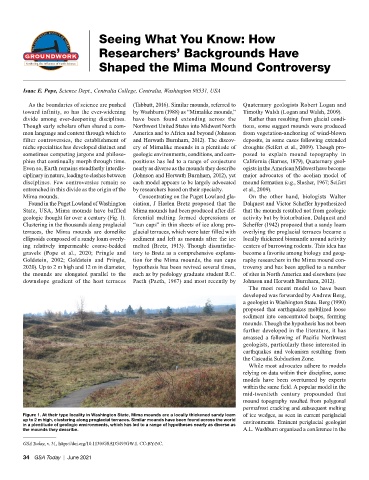
geologic thought for over a century (Fig. 1). ferential melting formed depressions or activity but by bioturbation. Dalquest and
Clustering in the thousands along proglacial “sun cups” in thin sheets of ice along pro- Scheffer (1942) proposed that a sandy loam
terraces, the Mima mounds are domelike glacial terraces, which were later filled with overlying the proglacial terraces became a
ellipsoids composed of a sandy loam overly- sediment and left as mounds after the ice locally thickened biomantle around activity
ing relatively impermeable coarse-bedded melted (Bretz, 1913). Though dissatisfac- centers of burrowing rodents. This idea has
gravels (Pope et al., 2020; Pringle and tory to Bretz as a comprehensive explana- become a favorite among biology and geog-
Goldstein, 2002; Goldstein and Pringle, tion for the Mima mounds, the sun cups raphy researchers in the Mima mound con-
2020). Up to 2 m high and 12 m in diameter, hypothesis has been revived several times, troversy and has been applied to a number
the mounds are elongated parallel to the such as by pedology graduate student R.C. of sites in North America and elsewhere (see
downslope gradient of the host terraces Paeth (Paeth, 1967) and most recently by Johnson and Horwath Burnham, 2012).
The most recent model to have been
developed was forwarded by Andrew Berg,
a geologist in Washington State. Berg (1990)
proposed that earthquakes mobilized loose
sediment into concentrated heaps, forming
mounds. Though the hypothesis has not been
further developed in the literature, it has
amassed a following of Pacific Northwest
geologists, particularly those interested in
earthquakes and volcanism resulting from
the Cascadia Subduction Zone.
While most advocates adhere to models
relying on data within their discipline, some
models have been overturned by experts
within the same field. A popular model in the
mid-twentieth century propounded that
mound topography resulted from polygonal
permafrost cracking and subsequent melting
Figure 1. At their type locality in Washington State, Mima mounds are a locally thickened sandy loam of ice wedges, as seen in current periglacial
up to 2 m high, clustering along proglacial terraces. Similar mounds have been found across the world environments. Eminent periglacial geologist
in a plentitude of geologic environments, which has led to a range of hypotheses nearly as diverse as
the mounds they describe. A.L. Washburn organized a conference in the
GSA Today, v. 31, https://doi.org/10.1130/GSATG493GW.1. CC-BY-NC.
34 GSA Today | June 2021