
Page 9 - 1052-5173-27-11
P. 9
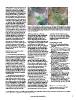
2012). Although some aspects of the Great      Figure 2. Landsat images of Las Vegas, Nevada, USA, in 1984 (left) and 2016 (right) showing the loss
Acceleration are predicted to plateau (pop-    of light-colored Quaternary wetland deposits to urban expansion. The boundaries of Tule Springs
ulation), other factors such as primary        Fossil Beds National Monument (TUSK), which preserve nearly 23,000 acres of the wetland depos-
energy use (energy consumption) show no        its, are shown in the righthand image. Images are courtesy of the Earth Resources Observation and
sign of slowing down. In other words, even     Science (EROS) Center.
though global population is predicted to
level off perhaps around 10 billion by the     valley were paved over or otherwise           now. Now is also the time to focus on
end of this century, increases in the extrac-  destroyed during the urban expansion (Fig.    training the next generation of geologists
tion and utilization of Earth’s resources are  2). Hundreds of square kilometers of the      because it can take years to hone the skills
predicted to continue (Steffen et al., 2015).  deposits were wiped out in just three         required to interpret and decipher these
                                               decades. Fortunately, the last contiguous     complex records.
  Humans are now the dominant geomor-          vestiges of the Las Vegas deposits, spanning
phic agent on Earth, transporting more         nearly 23,000 acres, were protected in 2014   REFERENCES CITED
sediment with heavy equipment than the         as Tule Springs Fossil Beds National
combined actions of water, wind, and ice       Monument. Owing to their preservation and     Hooke, R.L., 1994, On the efficacy of humans
(Hooke et al., 2012; Hooke, 1994). But it      subsequent study, we now know that these         as geomorphic agents: GSA Today, v. 4, no. 9,
is not just bulldozers that are affecting the  deposits provide some of the most detailed       p. 224–226.
surficial geologic record. Topsoil and sur-    records for understanding how desert wet-
ficial sediments are being disturbed and       land ecosystems responded to abrupt climate   Hooke, R.L., Martin-Duque, J.F., and Pedraza, J.,
eroded at unprecedented scales by con-         change during the late Quaternary (Springer      2012, Land transformation by humans: A review:
ventional agriculture, increasing rates of     et al., 2015). Had the monument not been         GSA Today, v. 22, no. 12, p. 4–10, doi:10.1130/
erosion by orders of magnitude over            established, such studies would not have         GSAT151A.1.
background levels (Montgomery, 2007).          been possible.
Alteration of Earth’s surface is also                                                        Montgomery, D.R., 2007, Is agriculture eroding
occurring at a rapid pace in urban and           The preservation of the Las Vegas              civilization’s foundation?: GSA Today, v. 17,
suburban areas, as well as coastal regions,    deposits is an exception rather than the         no. 10, p. 4–9, doi:10.1130/GSAT01710A.1.
in step with increases in global popula-       rule as the Great Acceleration marches on.
tion, GDP, and primary energy use, lead-       Even in the most remote areas on Earth,       Springer, K.B., Manker, C.R., and Pigati, J.S.,
ing to the widespread loss of the surficial    from the high Arctic to the driest deserts,      2015, Dynamic response of desert wetlands to
geologic record.                               we are seeing massive alterations of the         abrupt climate change: Proceedings of the
                                               landscape due to the extraction of               National Academy of Sciences USA, v. 112,
IDENTIFYING AND STUDYING                       resources to meet human demands. We              no. 47, p. 14,522–14,526, doi:10.1073/
AT-RISK DEPOSITS                               suggest that Google’s Timelapse feature          pnas.1513352112.
                                               can be used in concert with surficial geo-
  It is imperative that geoscientists iden-    logic maps to identify locations where        Steffen, W., Sanderson, R.A., Tyson, P.D., Jäger, J.,
tify areas containing surficial deposits that  deposits are threatened, allowing scientists     Matson, P.A., Moore, B., III, Oldfield, F.,
are most at risk. A new tool, the Timelapse    to study them before it is too late.             Richardson, K., Schellnhuber, H.-J., Turner,
feature in Google Earth Engine1, vividly                                                        B.L., and Wasson, R.J., 2004, Global Change
shows the remarkable impact that humans          A key concern and question is “How             and the Earth System: A Planet under Pressure:
are having on the landscape. Combining         much time do we have?” The answer                The IGBP Book Series: Berlin, Heidelberg, New
multiple sources of satellite imagery,         depends upon the prioritization of research      York, Springer-Verlag, 336 p.
Timelapse allows users to track changes,       questions, the availability of funding and
determine or follow trends, and quantify       resources, and the measures taken to pre-     Steffen, W., Broadgate, W., Deutsch, L., Gaffney,
differences in land use that have occurred     serve the deposits in select cases. Clearly,     O., and Ludwig, C., 2015, The trajectory of the
during a 32-year period (1984–2016). It is     for those interested in studying the surfi-      Anthropocene: The Great Acceleration: The
an especially timely and effective tool for    cial geologic record, the time to do so is       Anthropocene Review, v. 2, no. 1, p. 81–98,
geologists that are interested in studying                                                      doi:10.1177/2053019614564785.
surficial deposits.
                                                                                             Zalasiewicz, J., Crutzen, P., and Steffen, W., 2012,
  A particularly striking example of the                                                        The Anthropocene, in Gradstein, F.M., Ogg,
visual power of this new tool is the Las                                                        J.G., Schmitz, M., et al., eds., A Geological Time
Vegas Valley of southern Nevada. Since                                                          Scale 2012: Amsterdam, Elsevier, p. 1033–1040.
1980, Clark County (Las Vegas metropoli-
tan area) has experienced a nearly fivefold                                                  Manuscript received 31 March 2017
increase in population to over two million                                                   Revised manuscript received 15 July 2017
people. As the cities of Las Vegas, North                                                    Manuscript accepted 24 July 2017
Las Vegas, and Henderson burgeoned, fos-
sil-rich deposits associated with springs and
wetlands that once covered most of the

1 The Timelapse feature can be accessed online at https://earthengine.google.com/timelapse/. (Note that any use of trade, firm, or product names is for descriptive
purposes only and does not imply endorsement by the U.S. government.)

                                               www.geosociety.org/gsatoday                                                                                           9